You are here: Home > Network List > MN - MEDNET Project Stations List
> Station TIP Timpagrande, Italy > Earthquake Result Viewer
TIP Timpagrande, Italy - Earthquake Result Viewer
| Earthquake location: |
Ecuador |
| Earthquake latitude/longitude: |
-1.3/-77.3 |
| Earthquake time(UTC): |
2010/08/12 (224) 11:54:15 GMT |
| Earthquake Depth: |
207 km |
| Earthquake Magnitude: |
6.4 MB, 7.1 MW, 7.1 MW |
| Earthquake Catalog/Contributor: |
WHDF/NEIC |
|
| Network: |
MN MEDNET Project |
| Station: |
TIP Timpagrande, Italy |
| Lat/Lon: |
39.18 N/16.76 E |
| Elevation: |
789 m |
|
| Distance: |
93.9 deg |
| Az: |
50.999 deg |
| Baz: |
271.581 deg |
| Ray Param: |
0.04101096 |
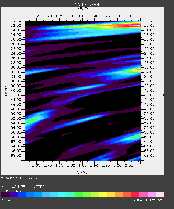
| Estimated Moho Depth: |
11.75 km |
| Estimated Crust Vp/Vs: |
2.10 |
| Assumed Crust Vp: |
6.1 km/s |
| Estimated Crust Vs: |
2.908 km/s |
| Estimated Crust Poisson's Ratio: |
0.35 |
|
| Radial Match: |
88.37932 % |
| Radial Bump: |
400 |
| Transverse Match: |
97.72933 % |
| Transverse Bump: |
221 |
| SOD ConfigId: |
319893 |
| Insert Time: |
2011-01-05 20:26:58.552 +0000 |
| GWidth: |
2.5 |
| Max Bumps: |
400 |
| Tol: |
0.001 |
|

Signal To Noise
| Channel | StoN | STA | LTA |
| MN:TIP: :BHZ:20100812T12:06:38.308027Z | 22.305656 | 9.0019915E-7 | 4.035744E-8 |
| MN:TIP: :BHN:20100812T12:06:38.308027Z | 18.945904 | 7.3718877E-7 | 3.891019E-8 |
| MN:TIP: :BHE:20100812T12:06:38.308027Z | 11.22021 | 3.5902247E-7 | 3.199784E-8 |
| Arrivals |
| Ps | 2.1 SECOND |
| PpPs | 5.9 SECOND |
| PsPs/PpSs | 8.0 SECOND |


