You are here: Home > Network List > NE - New England Seismic Network Stations List
> Station HNH Hanover, NH > Earthquake Result Viewer
HNH Hanover, NH - Earthquake Result Viewer
| Earthquake location: |
Ecuador |
| Earthquake latitude/longitude: |
-1.3/-77.3 |
| Earthquake time(UTC): |
2010/08/12 (224) 11:54:15 GMT |
| Earthquake Depth: |
207 km |
| Earthquake Magnitude: |
6.4 MB, 7.1 MW, 7.1 MW |
| Earthquake Catalog/Contributor: |
WHDF/NEIC |
|
| Network: |
NE New England Seismic Network |
| Station: |
HNH Hanover, NH |
| Lat/Lon: |
43.71 N/72.29 W |
| Elevation: |
180 m |
|
| Distance: |
45.0 deg |
| Az: |
5.149 deg |
| Baz: |
187.107 deg |
| Ray Param: |
0.070764825 |
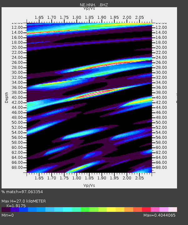
| Estimated Moho Depth: |
27.0 km |
| Estimated Crust Vp/Vs: |
1.92 |
| Assumed Crust Vp: |
6.419 km/s |
| Estimated Crust Vs: |
3.348 km/s |
| Estimated Crust Poisson's Ratio: |
0.31 |
|
| Radial Match: |
97.063354 % |
| Radial Bump: |
341 |
| Transverse Match: |
86.55561 % |
| Transverse Bump: |
400 |
| SOD ConfigId: |
319893 |
| Insert Time: |
2011-01-05 20:27:20.466 +0000 |
| GWidth: |
2.5 |
| Max Bumps: |
400 |
| Tol: |
0.001 |
|

Signal To Noise
| Channel | StoN | STA | LTA |
| NE:HNH: :BHZ:20100812T12:01:39.71501Z | 37.58572 | 9.261502E-6 | 2.464101E-7 |
| NE:HNH: :BHN:20100812T12:01:39.71501Z | 74.18013 | 4.9258483E-6 | 6.640388E-8 |
| NE:HNH: :BHE:20100812T12:01:39.71501Z | 13.755779 | 9.1309744E-7 | 6.637919E-8 |
| Arrivals |
| Ps | 4.1 SECOND |
| PpPs | 12 SECOND |
| PsPs/PpSs | 16 SECOND |


