You are here: Home > Network List > N4 - Central and EAstern US Network Stations List
> Station T42B T42B > Earthquake Result Viewer
T42B T42B - Earthquake Result Viewer
| Earthquake location: |
Central Peru |
| Earthquake latitude/longitude: |
-14.7/-70.1 |
| Earthquake time(UTC): |
2019/03/01 (060) 08:50:41 GMT |
| Earthquake Depth: |
257 km |
| Earthquake Magnitude: |
7.0 mww |
| Earthquake Catalog/Contributor: |
NEIC PDE/us |
|
| Network: |
N4 Central and EAstern US Network |
| Station: |
T42B T42B |
| Lat/Lon: |
37.03 N/91.09 W |
| Elevation: |
165 m |
|
| Distance: |
55.1 deg |
| Az: |
339.566 deg |
| Baz: |
155.027 deg |
| Ray Param: |
0.06410025 |
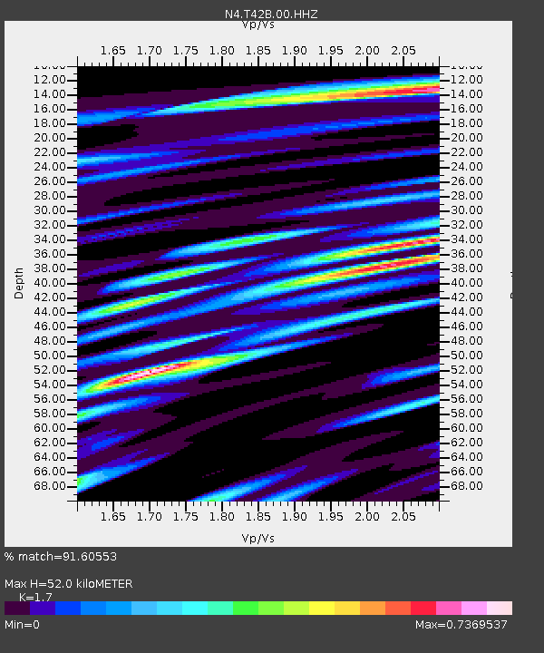
| Estimated Moho Depth: |
52.0 km |
| Estimated Crust Vp/Vs: |
1.70 |
| Assumed Crust Vp: |
6.53 km/s |
| Estimated Crust Vs: |
3.841 km/s |
| Estimated Crust Poisson's Ratio: |
0.24 |
|
| Radial Match: |
91.60553 % |
| Radial Bump: |
400 |
| Transverse Match: |
65.00572 % |
| Transverse Bump: |
400 |
| SOD ConfigId: |
3313551 |
| Insert Time: |
2019-03-15 09:05:28.348 +0000 |
| GWidth: |
2.5 |
| Max Bumps: |
400 |
| Tol: |
0.001 |
|

Signal To Noise
| Channel | StoN | STA | LTA |
| N4:T42B:00:HHZ:20190301T08:59:16.410005Z | 39.856865 | 5.667413E-6 | 1.4219415E-7 |
| N4:T42B:00:HH1:20190301T08:59:16.410005Z | 16.352087 | 2.4406152E-6 | 1.4925403E-7 |
| N4:T42B:00:HH2:20190301T08:59:16.410005Z | 8.564904 | 1.3904464E-6 | 1.6234233E-7 |
| Arrivals |
| Ps | 5.9 SECOND |
| PpPs | 20 SECOND |
| PsPs/PpSs | 26 SECOND |


