You are here: Home > Network List > TA - USArray Transportable Network (new EarthScope stations) Stations List
> Station MSTX Muleshoe, TX, USA > Earthquake Result Viewer
MSTX Muleshoe, TX, USA - Earthquake Result Viewer
| Earthquake location: |
Ecuador |
| Earthquake latitude/longitude: |
-1.3/-77.3 |
| Earthquake time(UTC): |
2010/08/12 (224) 11:54:15 GMT |
| Earthquake Depth: |
207 km |
| Earthquake Magnitude: |
6.4 MB, 7.1 MW, 7.1 MW |
| Earthquake Catalog/Contributor: |
WHDF/NEIC |
|
| Network: |
TA USArray Transportable Network (new EarthScope stations) |
| Station: |
MSTX Muleshoe, TX, USA |
| Lat/Lon: |
33.97 N/102.77 W |
| Elevation: |
1167 m |
|
| Distance: |
42.4 deg |
| Az: |
328.029 deg |
| Baz: |
140.433 deg |
| Ray Param: |
0.0723598 |
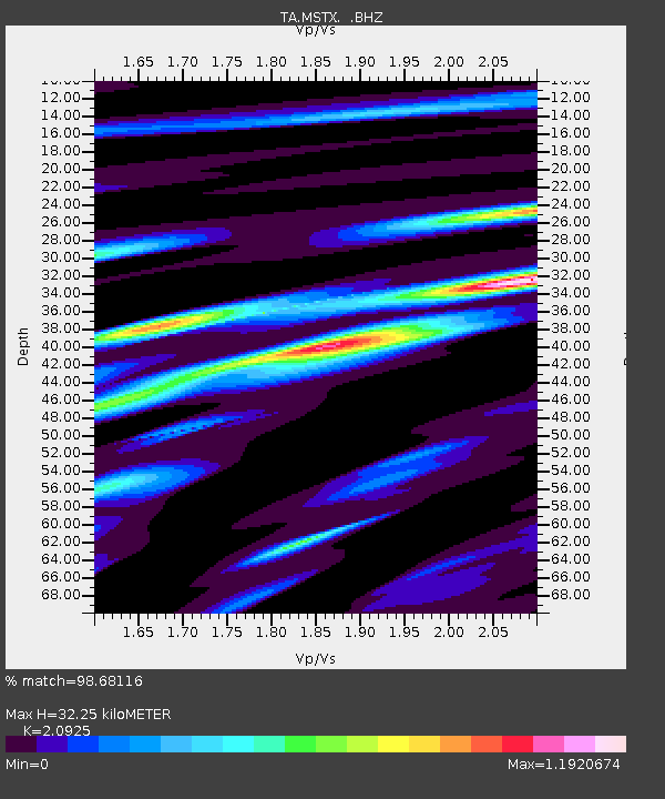
| Estimated Moho Depth: |
32.25 km |
| Estimated Crust Vp/Vs: |
2.09 |
| Assumed Crust Vp: |
6.129 km/s |
| Estimated Crust Vs: |
2.929 km/s |
| Estimated Crust Poisson's Ratio: |
0.35 |
|
| Radial Match: |
98.68116 % |
| Radial Bump: |
400 |
| Transverse Match: |
91.98498 % |
| Transverse Bump: |
400 |
| SOD ConfigId: |
319893 |
| Insert Time: |
2011-01-05 20:30:52.936 +0000 |
| GWidth: |
2.5 |
| Max Bumps: |
400 |
| Tol: |
0.001 |
|

Signal To Noise
| Channel | StoN | STA | LTA |
| TA:MSTX: :BHZ:20100812T12:01:19.449995Z | 79.276115 | 4.671667E-6 | 5.8929057E-8 |
| TA:MSTX: :BHN:20100812T12:01:19.449995Z | 18.374462 | 1.3818321E-6 | 7.520395E-8 |
| TA:MSTX: :BHE:20100812T12:01:19.449995Z | 17.172176 | 1.0304885E-6 | 6.00092E-8 |
| Arrivals |
| Ps | 6.0 SECOND |
| PpPs | 15 SECOND |
| PsPs/PpSs | 22 SECOND |


