You are here: Home > Network List > TA - USArray Transportable Network (new EarthScope stations) Stations List
> Station S22A 4UR Ranch, Creede, CO, USA > Earthquake Result Viewer
S22A 4UR Ranch, Creede, CO, USA - Earthquake Result Viewer
| Earthquake location: |
Ecuador |
| Earthquake latitude/longitude: |
-1.3/-77.3 |
| Earthquake time(UTC): |
2010/08/12 (224) 11:54:15 GMT |
| Earthquake Depth: |
207 km |
| Earthquake Magnitude: |
6.4 MB, 7.1 MW, 7.1 MW |
| Earthquake Catalog/Contributor: |
WHDF/NEIC |
|
| Network: |
TA USArray Transportable Network (new EarthScope stations) |
| Station: |
S22A 4UR Ranch, Creede, CO, USA |
| Lat/Lon: |
37.75 N/106.83 W |
| Elevation: |
2626 m |
|
| Distance: |
47.4 deg |
| Az: |
327.977 deg |
| Baz: |
138.029 deg |
| Ray Param: |
0.06921625 |
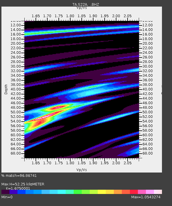
| Estimated Moho Depth: |
52.25 km |
| Estimated Crust Vp/Vs: |
1.68 |
| Assumed Crust Vp: |
6.159 km/s |
| Estimated Crust Vs: |
3.677 km/s |
| Estimated Crust Poisson's Ratio: |
0.22 |
|
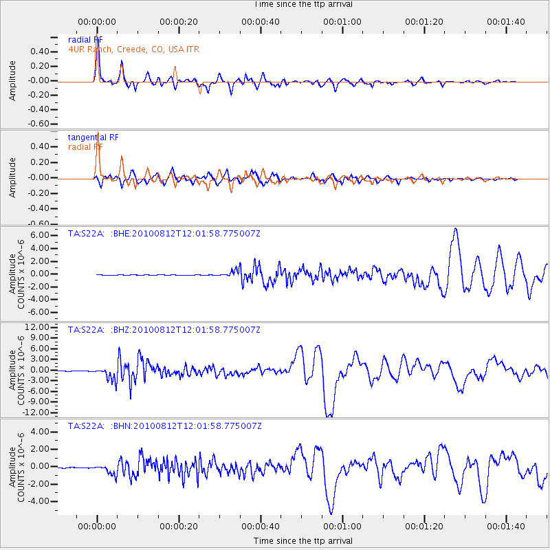
| Radial Match: |
96.86741 % |
| Radial Bump: |
399 |
| Transverse Match: |
92.10617 % |
| Transverse Bump: |
400 |
| SOD ConfigId: |
319893 |
| Insert Time: |
2011-01-05 20:31:05.165 +0000 |
| GWidth: |
2.5 |
| Max Bumps: |
400 |
| Tol: |
0.001 |
|
Signal To Noise
| Channel | StoN | STA | LTA |
| TA:S22A: :BHZ:20100812T12:01:58.775007Z | 41.15121 | 1.8459061E-6 | 4.4856666E-8 |
| TA:S22A: :BHN:20100812T12:01:58.775007Z | 15.413134 | 5.758522E-7 | 3.736114E-8 |
| TA:S22A: :BHE:20100812T12:01:58.775007Z | 13.564148 | 5.0814714E-7 | 3.7462517E-8 |
| Arrivals |
| Ps | 6.1 SECOND |
| PpPs | 21 SECOND |
| PsPs/PpSs | 27 SECOND |


