You are here: Home > Network List > TA - USArray Transportable Network (new EarthScope stations) Stations List
> Station H21A Big Horn, Sheridan, WY, USA > Earthquake Result Viewer
H21A Big Horn, Sheridan, WY, USA - Earthquake Result Viewer

| Earthquake location: |
Ecuador |
| Earthquake latitude/longitude: |
-1.3/-77.3 |
| Earthquake time(UTC): |
2010/08/12 (224) 11:54:15 GMT |
| Earthquake Depth: |
207 km |
| Earthquake Magnitude: |
6.4 MB, 7.1 MW, 7.1 MW |
| Earthquake Catalog/Contributor: |
WHDF/NEIC |
|
| Network: |
TA USArray Transportable Network (new EarthScope stations) |
| Station: |
H21A Big Horn, Sheridan, WY, USA |
| Lat/Lon: |
44.63 N/107.04 W |
| Elevation: |
1411 m |
|
| Distance: |
52.8 deg |
| Az: |
333.602 deg |
| Baz: |
141.501 deg |
| Ray Param: |
0.06577081 |
| Estimated Moho Depth: |
39.25 km |
| Estimated Crust Vp/Vs: |
1.76 |
| Assumed Crust Vp: |
6.178 km/s |
| Estimated Crust Vs: |
3.505 km/s |
| Estimated Crust Poisson's Ratio: |
0.26 |
|
| Radial Match: |
96.88583 % |
| Radial Bump: |
400 |
| Transverse Match: |
89.07694 % |
| Transverse Bump: |
400 |
| SOD ConfigId: |
319893 |
| Insert Time: |
2011-01-05 20:31:29.990 +0000 |
| GWidth: |
2.5 |
| Max Bumps: |
400 |
| Tol: |
0.001 |
|
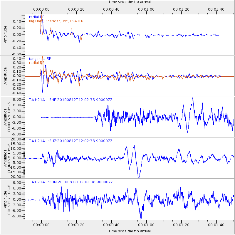
Signal To Noise
| Channel | StoN | STA | LTA |
| TA:H21A: :BHZ:20100812T12:02:38.900007Z | 45.533894 | 3.3756658E-6 | 7.413524E-8 |
| TA:H21A: :BHN:20100812T12:02:38.900007Z | 13.056257 | 1.063998E-6 | 8.149333E-8 |
| TA:H21A: :BHE:20100812T12:02:38.900007Z | 16.78809 | 1.6721382E-6 | 9.960264E-8 |
| Arrivals |
| Ps | 5.1 SECOND |
| PpPs | 17 SECOND |
| PsPs/PpSs | 22 SECOND |


