You are here: Home > Network List > TA - USArray Transportable Network (new EarthScope stations) Stations List
> Station H19A Powell, WY, USA > Earthquake Result Viewer
H19A Powell, WY, USA - Earthquake Result Viewer

| Earthquake location: |
Ecuador |
| Earthquake latitude/longitude: |
-1.3/-77.3 |
| Earthquake time(UTC): |
2010/08/12 (224) 11:54:15 GMT |
| Earthquake Depth: |
207 km |
| Earthquake Magnitude: |
6.4 MB, 7.1 MW, 7.1 MW |
| Earthquake Catalog/Contributor: |
WHDF/NEIC |
|
| Network: |
TA USArray Transportable Network (new EarthScope stations) |
| Station: |
H19A Powell, WY, USA |
| Lat/Lon: |
44.67 N/108.99 W |
| Elevation: |
1479 m |
|
| Distance: |
53.7 deg |
| Az: |
332.302 deg |
| Baz: |
139.362 deg |
| Ray Param: |
0.06519646 |
| Estimated Moho Depth: |
10.0 km |
| Estimated Crust Vp/Vs: |
1.79 |
| Assumed Crust Vp: |
6.242 km/s |
| Estimated Crust Vs: |
3.497 km/s |
| Estimated Crust Poisson's Ratio: |
0.27 |
|
| Radial Match: |
94.14091 % |
| Radial Bump: |
380 |
| Transverse Match: |
90.23753 % |
| Transverse Bump: |
400 |
| SOD ConfigId: |
319893 |
| Insert Time: |
2011-01-05 20:32:18.569 +0000 |
| GWidth: |
2.5 |
| Max Bumps: |
400 |
| Tol: |
0.001 |
|
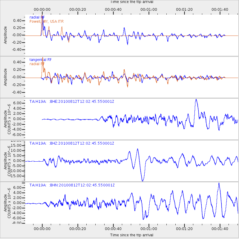
Signal To Noise
| Channel | StoN | STA | LTA |
| TA:H19A: :BHZ:20100812T12:02:45.550001Z | 25.824337 | 1.9779536E-6 | 7.659262E-8 |
| TA:H19A: :BHN:20100812T12:02:45.550001Z | 5.4152946 | 5.2035267E-7 | 9.6089444E-8 |
| TA:H19A: :BHE:20100812T12:02:45.550001Z | 4.568187 | 4.718711E-7 | 1.03295044E-7 |
| Arrivals |
| Ps | 1.3 SECOND |
| PpPs | 4.2 SECOND |
| PsPs/PpSs | 5.6 SECOND |


