You are here: Home > Network List > TA - USArray Transportable Network (new EarthScope stations) Stations List
> Station G20A Bridger, MT, USA > Earthquake Result Viewer
G20A Bridger, MT, USA - Earthquake Result Viewer
| Earthquake location: |
Ecuador |
| Earthquake latitude/longitude: |
-1.3/-77.3 |
| Earthquake time(UTC): |
2010/08/12 (224) 11:54:15 GMT |
| Earthquake Depth: |
207 km |
| Earthquake Magnitude: |
6.4 MB, 7.1 MW, 7.1 MW |
| Earthquake Catalog/Contributor: |
WHDF/NEIC |
|
| Network: |
TA USArray Transportable Network (new EarthScope stations) |
| Station: |
G20A Bridger, MT, USA |
| Lat/Lon: |
45.22 N/108.21 W |
| Elevation: |
1431 m |
|
| Distance: |
53.8 deg |
| Az: |
333.261 deg |
| Baz: |
140.472 deg |
| Ray Param: |
0.06515184 |
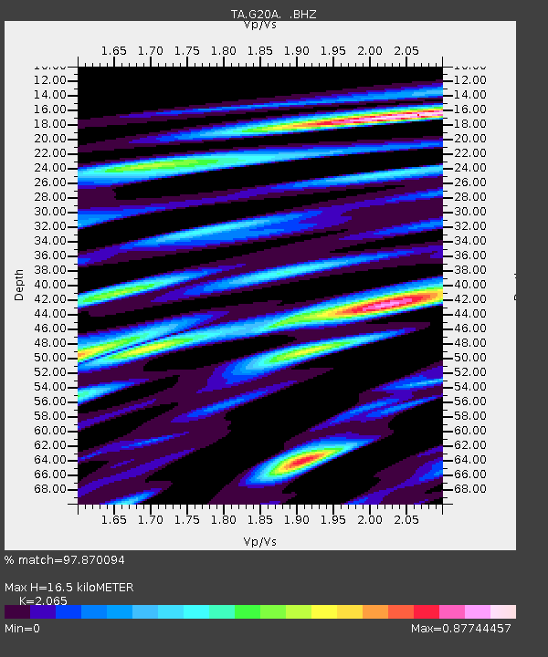
| Estimated Moho Depth: |
16.5 km |
| Estimated Crust Vp/Vs: |
2.07 |
| Assumed Crust Vp: |
6.242 km/s |
| Estimated Crust Vs: |
3.023 km/s |
| Estimated Crust Poisson's Ratio: |
0.35 |
|
| Radial Match: |
97.870094 % |
| Radial Bump: |
400 |
| Transverse Match: |
92.69273 % |
| Transverse Bump: |
400 |
| SOD ConfigId: |
319893 |
| Insert Time: |
2011-01-05 20:32:25.644 +0000 |
| GWidth: |
2.5 |
| Max Bumps: |
400 |
| Tol: |
0.001 |
|

Signal To Noise
| Channel | StoN | STA | LTA |
| TA:G20A: :BHZ:20100812T12:02:46.025007Z | 40.419575 | 2.2707686E-6 | 5.617992E-8 |
| TA:G20A: :BHN:20100812T12:02:46.025007Z | 25.515333 | 1.1274498E-6 | 4.4187146E-8 |
| TA:G20A: :BHE:20100812T12:02:46.025007Z | 24.011183 | 8.982965E-7 | 3.741159E-8 |
| Arrivals |
| Ps | 2.9 SECOND |
| PpPs | 7.8 SECOND |
| PsPs/PpSs | 11 SECOND |


