You are here: Home > Network List > TA - USArray Transportable Network (new EarthScope stations) Stations List
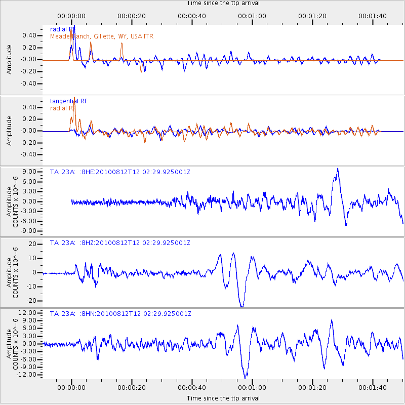
> Station I23A Meade Ranch, Gillette, WY, USA > Earthquake Result Viewer
I23A Meade Ranch, Gillette, WY, USA - Earthquake Result Viewer
| Earthquake location: |
Ecuador |
| Earthquake latitude/longitude: |
-1.3/-77.3 |
| Earthquake time(UTC): |
2010/08/12 (224) 11:54:15 GMT |
| Earthquake Depth: |
207 km |
| Earthquake Magnitude: |
6.4 MB, 7.1 MW, 7.1 MW |
| Earthquake Catalog/Contributor: |
WHDF/NEIC |
|
| Network: |
TA USArray Transportable Network (new EarthScope stations) |
| Station: |
I23A Meade Ranch, Gillette, WY, USA |
| Lat/Lon: |
43.96 N/105.46 W |
| Elevation: |
1462 m |
|
| Distance: |
51.6 deg |
| Az: |
334.22 deg |
| Baz: |
142.979 deg |
| Ray Param: |
0.06657494 |
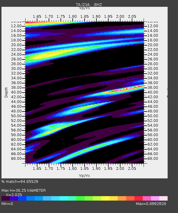
| Estimated Moho Depth: |
38.25 km |
| Estimated Crust Vp/Vs: |
2.03 |
| Assumed Crust Vp: |
6.159 km/s |
| Estimated Crust Vs: |
3.041 km/s |
| Estimated Crust Poisson's Ratio: |
0.34 |
|
| Radial Match: |
94.85529 % |
| Radial Bump: |
400 |
| Transverse Match: |
87.05778 % |
| Transverse Bump: |
400 |
| SOD ConfigId: |
319893 |
| Insert Time: |
2011-01-05 20:33:01.446 +0000 |
| GWidth: |
2.5 |
| Max Bumps: |
400 |
| Tol: |
0.001 |
|
Signal To Noise
| Channel | StoN | STA | LTA |
| TA:I23A: :BHZ:20100812T12:02:29.925001Z | 12.264966 | 3.3716653E-6 | 2.7490213E-7 |
| TA:I23A: :BHN:20100812T12:02:29.925001Z | 2.7615774 | 1.005535E-6 | 3.6411618E-7 |
| TA:I23A: :BHE:20100812T12:02:29.925001Z | 1.6615005 | 6.600247E-7 | 3.9724617E-7 |
| Arrivals |
| Ps | 6.7 SECOND |
| PpPs | 18 SECOND |
| PsPs/PpSs | 25 SECOND |


