You are here: Home > Network List > TA - USArray Transportable Network (new EarthScope stations) Stations List
> Station H24A Dirks Ranch, Alva, WY, USA > Earthquake Result Viewer
H24A Dirks Ranch, Alva, WY, USA - Earthquake Result Viewer
| Earthquake location: |
Ecuador |
| Earthquake latitude/longitude: |
-1.3/-77.3 |
| Earthquake time(UTC): |
2010/08/12 (224) 11:54:15 GMT |
| Earthquake Depth: |
207 km |
| Earthquake Magnitude: |
6.4 MB, 7.1 MW, 7.1 MW |
| Earthquake Catalog/Contributor: |
WHDF/NEIC |
|
| Network: |
TA USArray Transportable Network (new EarthScope stations) |
| Station: |
H24A Dirks Ranch, Alva, WY, USA |
| Lat/Lon: |
44.75 N/104.55 W |
| Elevation: |
1166 m |
|
| Distance: |
51.8 deg |
| Az: |
335.484 deg |
| Baz: |
144.396 deg |
| Ray Param: |
0.06641407 |
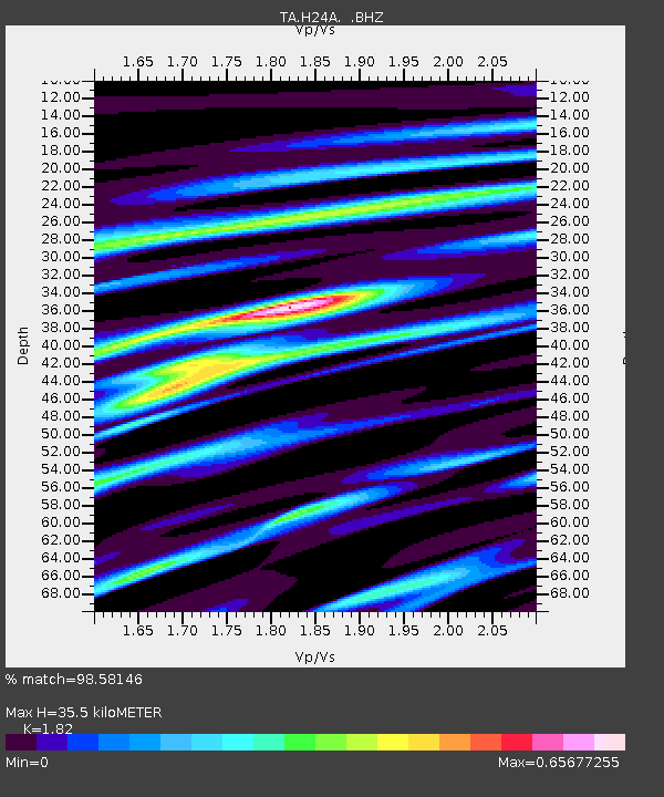
| Estimated Moho Depth: |
35.5 km |
| Estimated Crust Vp/Vs: |
1.82 |
| Assumed Crust Vp: |
6.242 km/s |
| Estimated Crust Vs: |
3.43 km/s |
| Estimated Crust Poisson's Ratio: |
0.28 |
|
| Radial Match: |
98.58146 % |
| Radial Bump: |
375 |
| Transverse Match: |
90.12602 % |
| Transverse Bump: |
400 |
| SOD ConfigId: |
319893 |
| Insert Time: |
2011-01-05 20:33:18.163 +0000 |
| GWidth: |
2.5 |
| Max Bumps: |
400 |
| Tol: |
0.001 |
|

Signal To Noise
| Channel | StoN | STA | LTA |
| TA:H24A: :BHZ:20100812T12:02:31.750013Z | 53.90936 | 2.637188E-6 | 4.8918924E-8 |
| TA:H24A: :BHN:20100812T12:02:31.750013Z | 16.689863 | 1.0395612E-6 | 6.2286986E-8 |
| TA:H24A: :BHE:20100812T12:02:31.750013Z | 24.177107 | 9.0773267E-7 | 3.754513E-8 |
| Arrivals |
| Ps | 4.9 SECOND |
| PpPs | 15 SECOND |
| PsPs/PpSs | 20 SECOND |


