You are here: Home > Network List > TA - USArray Transportable Network (new EarthScope stations) Stations List
> Station K27A Flueckinger Farm, Gordon, NE, USA > Earthquake Result Viewer
K27A Flueckinger Farm, Gordon, NE, USA - Earthquake Result Viewer
| Earthquake location: |
Ecuador |
| Earthquake latitude/longitude: |
-1.3/-77.3 |
| Earthquake time(UTC): |
2010/08/12 (224) 11:54:15 GMT |
| Earthquake Depth: |
207 km |
| Earthquake Magnitude: |
6.4 MB, 7.1 MW, 7.1 MW |
| Earthquake Catalog/Contributor: |
WHDF/NEIC |
|
| Network: |
TA USArray Transportable Network (new EarthScope stations) |
| Station: |
K27A Flueckinger Farm, Gordon, NE, USA |
| Lat/Lon: |
42.70 N/102.24 W |
| Elevation: |
1131 m |
|
| Distance: |
49.2 deg |
| Az: |
335.765 deg |
| Baz: |
146.171 deg |
| Ray Param: |
0.06809938 |
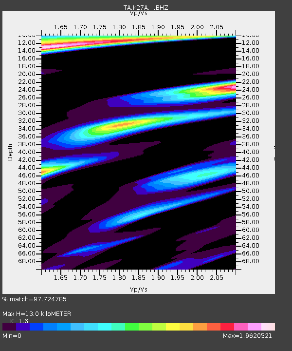
| Estimated Moho Depth: |
13.0 km |
| Estimated Crust Vp/Vs: |
1.60 |
| Assumed Crust Vp: |
6.483 km/s |
| Estimated Crust Vs: |
4.052 km/s |
| Estimated Crust Poisson's Ratio: |
0.18 |
|
| Radial Match: |
97.724785 % |
| Radial Bump: |
400 |
| Transverse Match: |
89.557884 % |
| Transverse Bump: |
400 |
| SOD ConfigId: |
319893 |
| Insert Time: |
2011-01-05 20:33:59.305 +0000 |
| GWidth: |
2.5 |
| Max Bumps: |
400 |
| Tol: |
0.001 |
|

Signal To Noise
| Channel | StoN | STA | LTA |
| TA:K27A: :BHZ:20100812T12:02:12.099989Z | 111.726616 | 6.683085E-6 | 5.981641E-8 |
| TA:K27A: :BHN:20100812T12:02:12.099989Z | 36.843346 | 3.5865323E-6 | 9.7345456E-8 |
| TA:K27A: :BHE:20100812T12:02:12.099989Z | 24.073463 | 3.421631E-6 | 1.4213289E-7 |
| Arrivals |
| Ps | 1.3 SECOND |
| PpPs | 4.9 SECOND |
| PsPs/PpSs | 6.2 SECOND |


