You are here: Home > Network List > TA - USArray Transportable Network (new EarthScope stations) Stations List
> Station L25A Engebretsen Ranch, Morrill, NE, USA > Earthquake Result Viewer
L25A Engebretsen Ranch, Morrill, NE, USA - Earthquake Result Viewer
| Earthquake location: |
Ecuador |
| Earthquake latitude/longitude: |
-1.3/-77.3 |
| Earthquake time(UTC): |
2010/08/12 (224) 11:54:15 GMT |
| Earthquake Depth: |
207 km |
| Earthquake Magnitude: |
6.4 MB, 7.1 MW, 7.1 MW |
| Earthquake Catalog/Contributor: |
WHDF/NEIC |
|
| Network: |
TA USArray Transportable Network (new EarthScope stations) |
| Station: |
L25A Engebretsen Ranch, Morrill, NE, USA |
| Lat/Lon: |
42.15 N/103.97 W |
| Elevation: |
1379 m |
|
| Distance: |
49.5 deg |
| Az: |
333.968 deg |
| Baz: |
143.837 deg |
| Ray Param: |
0.06790998 |
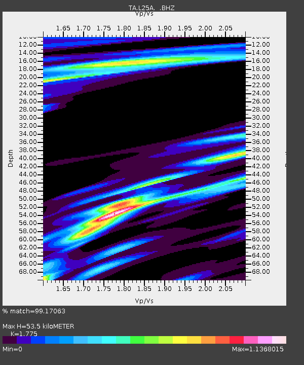
| Estimated Moho Depth: |
53.5 km |
| Estimated Crust Vp/Vs: |
1.77 |
| Assumed Crust Vp: |
6.483 km/s |
| Estimated Crust Vs: |
3.652 km/s |
| Estimated Crust Poisson's Ratio: |
0.27 |
|
| Radial Match: |
99.17063 % |
| Radial Bump: |
238 |
| Transverse Match: |
94.64458 % |
| Transverse Bump: |
361 |
| SOD ConfigId: |
319893 |
| Insert Time: |
2011-01-05 20:34:14.320 +0000 |
| GWidth: |
2.5 |
| Max Bumps: |
400 |
| Tol: |
0.001 |
|
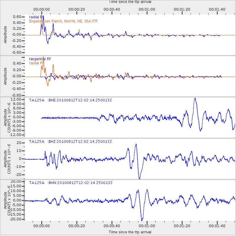
Signal To Noise
| Channel | StoN | STA | LTA |
| TA:L25A: :BHZ:20100812T12:02:14.250013Z | 21.037252 | 4.260349E-6 | 2.0251451E-7 |
| TA:L25A: :BHN:20100812T12:02:14.250013Z | 5.57391 | 1.2484045E-6 | 2.2397285E-7 |
| TA:L25A: :BHE:20100812T12:02:14.250013Z | 4.616201 | 8.3771675E-7 | 1.814732E-7 |
| Arrivals |
| Ps | 6.8 SECOND |
| PpPs | 22 SECOND |
| PsPs/PpSs | 28 SECOND |


