You are here: Home > Network List > TA - USArray Transportable Network (new EarthScope stations) Stations List
> Station G23A Biddle, MT, USA > Earthquake Result Viewer
G23A Biddle, MT, USA - Earthquake Result Viewer
| Earthquake location: |
Ecuador |
| Earthquake latitude/longitude: |
-1.3/-77.3 |
| Earthquake time(UTC): |
2010/08/12 (224) 11:54:15 GMT |
| Earthquake Depth: |
207 km |
| Earthquake Magnitude: |
6.4 MB, 7.1 MW, 7.1 MW |
| Earthquake Catalog/Contributor: |
WHDF/NEIC |
|
| Network: |
TA USArray Transportable Network (new EarthScope stations) |
| Station: |
G23A Biddle, MT, USA |
| Lat/Lon: |
45.20 N/105.39 W |
| Elevation: |
1064 m |
|
| Distance: |
52.5 deg |
| Az: |
335.212 deg |
| Baz: |
143.639 deg |
| Ray Param: |
0.065941006 |
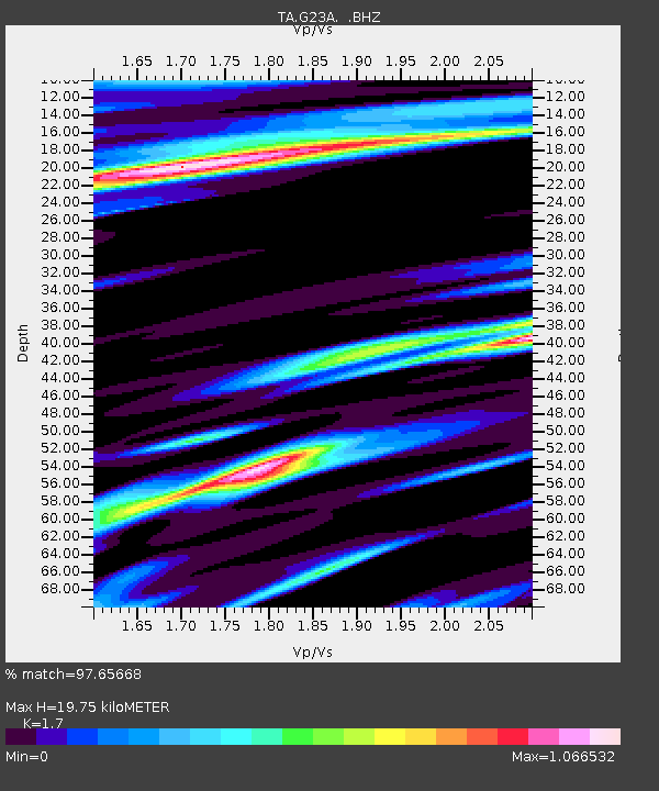
| Estimated Moho Depth: |
19.75 km |
| Estimated Crust Vp/Vs: |
1.70 |
| Assumed Crust Vp: |
6.242 km/s |
| Estimated Crust Vs: |
3.672 km/s |
| Estimated Crust Poisson's Ratio: |
0.24 |
|
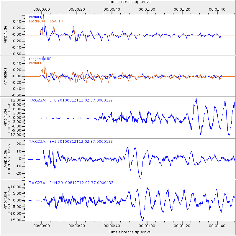
| Radial Match: |
97.65668 % |
| Radial Bump: |
349 |
| Transverse Match: |
95.448586 % |
| Transverse Bump: |
400 |
| SOD ConfigId: |
319893 |
| Insert Time: |
2011-01-05 20:34:22.014 +0000 |
| GWidth: |
2.5 |
| Max Bumps: |
400 |
| Tol: |
0.001 |
|
Signal To Noise
| Channel | StoN | STA | LTA |
| TA:G23A: :BHZ:20100812T12:02:37.000013Z | 40.777756 | 5.1875068E-6 | 1.2721412E-7 |
| TA:G23A: :BHN:20100812T12:02:37.000013Z | 12.612773 | 1.5453354E-6 | 1.2252147E-7 |
| TA:G23A: :BHE:20100812T12:02:37.000013Z | 7.237866 | 8.7837145E-7 | 1.213578E-7 |
| Arrivals |
| Ps | 2.3 SECOND |
| PpPs | 8.1 SECOND |
| PsPs/PpSs | 10 SECOND |


