You are here: Home > Network List > TX - Texas Seismological Network Stations List
> Station MNHN Monahans > Earthquake Result Viewer
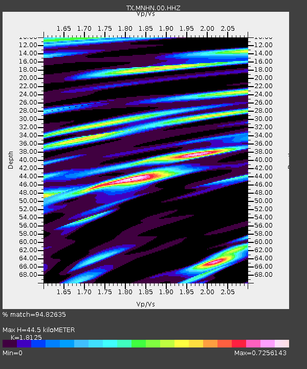
MNHN Monahans - Earthquake Result Viewer
| Earthquake location: |
Central Peru |
| Earthquake latitude/longitude: |
-14.7/-70.1 |
| Earthquake time(UTC): |
2019/03/01 (060) 08:50:41 GMT |
| Earthquake Depth: |
257 km |
| Earthquake Magnitude: |
7.0 mww |
| Earthquake Catalog/Contributor: |
NEIC PDE/us |
|
| Network: |
TX Texas Seismological Network |
| Station: |
MNHN Monahans |
| Lat/Lon: |
31.34 N/102.76 W |
| Elevation: |
750 m |
|
| Distance: |
55.5 deg |
| Az: |
325.934 deg |
| Baz: |
140.688 deg |
| Ray Param: |
0.063867845 |
| Estimated Moho Depth: |
44.5 km |
| Estimated Crust Vp/Vs: |
1.81 |
| Assumed Crust Vp: |
6.121 km/s |
| Estimated Crust Vs: |
3.377 km/s |
| Estimated Crust Poisson's Ratio: |
0.28 |
|
| Radial Match: |
94.82635 % |
| Radial Bump: |
400 |
| Transverse Match: |
85.511475 % |
| Transverse Bump: |
400 |
| SOD ConfigId: |
3313551 |
| Insert Time: |
2019-03-15 09:07:16.315 +0000 |
| GWidth: |
2.5 |
| Max Bumps: |
400 |
| Tol: |
0.001 |
|

Signal To Noise
| Channel | StoN | STA | LTA |
| TX:MNHN:00:HHZ:20190301T08:59:18.964998Z | 29.511497 | 6.25988E-6 | 2.1211665E-7 |
| TX:MNHN:00:HH1:20190301T08:59:18.964998Z | 15.335268 | 1.7908901E-6 | 1.16782445E-7 |
| TX:MNHN:00:HH2:20190301T08:59:18.964998Z | 10.689946 | 2.549725E-6 | 2.3851618E-7 |
| Arrivals |
| Ps | 6.2 SECOND |
| PpPs | 20 SECOND |
| PsPs/PpSs | 26 SECOND |


