You are here: Home > Network List > TA - USArray Transportable Network (new EarthScope stations) Stations List
> Station W28A Vega, TX, USA > Earthquake Result Viewer
W28A Vega, TX, USA - Earthquake Result Viewer

| Earthquake location: |
Ecuador |
| Earthquake latitude/longitude: |
-1.3/-77.3 |
| Earthquake time(UTC): |
2010/08/12 (224) 11:54:15 GMT |
| Earthquake Depth: |
207 km |
| Earthquake Magnitude: |
6.4 MB, 7.1 MW, 7.1 MW |
| Earthquake Catalog/Contributor: |
WHDF/NEIC |
|
| Network: |
TA USArray Transportable Network (new EarthScope stations) |
| Station: |
W28A Vega, TX, USA |
| Lat/Lon: |
35.26 N/102.21 W |
| Elevation: |
1156 m |
|
| Distance: |
43.2 deg |
| Az: |
329.749 deg |
| Baz: |
142.016 deg |
| Ray Param: |
0.07192041 |
| Estimated Moho Depth: |
60.25 km |
| Estimated Crust Vp/Vs: |
1.60 |
| Assumed Crust Vp: |
6.242 km/s |
| Estimated Crust Vs: |
3.901 km/s |
| Estimated Crust Poisson's Ratio: |
0.18 |
|
| Radial Match: |
97.210365 % |
| Radial Bump: |
319 |
| Transverse Match: |
87.27518 % |
| Transverse Bump: |
400 |
| SOD ConfigId: |
319893 |
| Insert Time: |
2011-01-05 20:35:50.008 +0000 |
| GWidth: |
2.5 |
| Max Bumps: |
400 |
| Tol: |
0.001 |
|
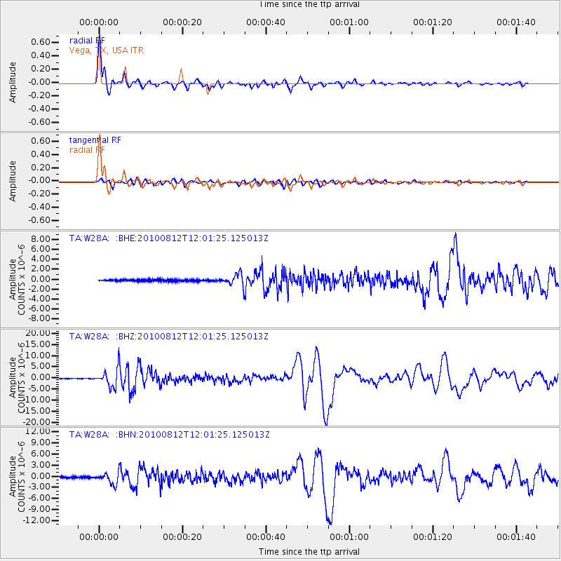
Signal To Noise
| Channel | StoN | STA | LTA |
| TA:W28A: :BHZ:20100812T12:01:25.125013Z | 41.877247 | 4.135131E-6 | 9.8744096E-8 |
| TA:W28A: :BHN:20100812T12:01:25.125013Z | 9.6658535 | 1.5383663E-6 | 1.5915474E-7 |
| TA:W28A: :BHE:20100812T12:01:25.125013Z | 7.718826 | 1.2069609E-6 | 1.5636586E-7 |
| Arrivals |
| Ps | 6.2 SECOND |
| PpPs | 23 SECOND |
| PsPs/PpSs | 30 SECOND |


