You are here: Home > Network List > TX - Texas Seismological Network Stations List
> Station SMWD Samnorwood > Earthquake Result Viewer
SMWD Samnorwood - Earthquake Result Viewer
| Earthquake location: |
Central Peru |
| Earthquake latitude/longitude: |
-14.7/-70.1 |
| Earthquake time(UTC): |
2019/03/01 (060) 08:50:41 GMT |
| Earthquake Depth: |
257 km |
| Earthquake Magnitude: |
7.0 mww |
| Earthquake Catalog/Contributor: |
NEIC PDE/us |
|
| Network: |
TX Texas Seismological Network |
| Station: |
SMWD Samnorwood |
| Lat/Lon: |
35.10 N/100.24 W |
| Elevation: |
704 m |
|
| Distance: |
57.2 deg |
| Az: |
330.686 deg |
| Baz: |
144.699 deg |
| Ray Param: |
0.06278408 |
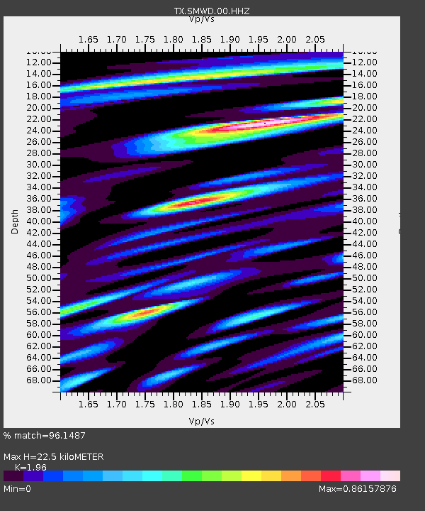
| Estimated Moho Depth: |
22.5 km |
| Estimated Crust Vp/Vs: |
1.96 |
| Assumed Crust Vp: |
6.426 km/s |
| Estimated Crust Vs: |
3.279 km/s |
| Estimated Crust Poisson's Ratio: |
0.32 |
|
| Radial Match: |
96.1487 % |
| Radial Bump: |
357 |
| Transverse Match: |
94.25921 % |
| Transverse Bump: |
375 |
| SOD ConfigId: |
3313551 |
| Insert Time: |
2019-03-15 09:07:42.688 +0000 |
| GWidth: |
2.5 |
| Max Bumps: |
400 |
| Tol: |
0.001 |
|

Signal To Noise
| Channel | StoN | STA | LTA |
| TX:SMWD:00:HHZ:20190301T08:59:30.944978Z | 43.234085 | 7.459576E-6 | 1.7253925E-7 |
| TX:SMWD:00:HH1:20190301T08:59:30.944978Z | 21.29498 | 4.006831E-6 | 1.881585E-7 |
| TX:SMWD:00:HH2:20190301T08:59:30.944978Z | 9.118591 | 2.1992312E-6 | 2.41181E-7 |
| Arrivals |
| Ps | 3.5 SECOND |
| PpPs | 9.9 SECOND |
| PsPs/PpSs | 13 SECOND |


