You are here: Home > Network List > TA - USArray Transportable Network (new EarthScope stations) Stations List
> Station 130A Snyder, TX, USA > Earthquake Result Viewer
130A Snyder, TX, USA - Earthquake Result Viewer

| Earthquake location: |
Ecuador |
| Earthquake latitude/longitude: |
-1.3/-77.3 |
| Earthquake time(UTC): |
2010/08/12 (224) 11:54:15 GMT |
| Earthquake Depth: |
207 km |
| Earthquake Magnitude: |
6.4 MB, 7.1 MW, 7.1 MW |
| Earthquake Catalog/Contributor: |
WHDF/NEIC |
|
| Network: |
TA USArray Transportable Network (new EarthScope stations) |
| Station: |
130A Snyder, TX, USA |
| Lat/Lon: |
32.60 N/100.97 W |
| Elevation: |
676 m |
|
| Distance: |
40.4 deg |
| Az: |
328.51 deg |
| Baz: |
141.781 deg |
| Ray Param: |
0.07359327 |
| Estimated Moho Depth: |
33.25 km |
| Estimated Crust Vp/Vs: |
2.05 |
| Assumed Crust Vp: |
6.426 km/s |
| Estimated Crust Vs: |
3.131 km/s |
| Estimated Crust Poisson's Ratio: |
0.34 |
|
| Radial Match: |
98.598495 % |
| Radial Bump: |
285 |
| Transverse Match: |
89.8512 % |
| Transverse Bump: |
400 |
| SOD ConfigId: |
319893 |
| Insert Time: |
2011-01-05 20:38:17.151 +0000 |
| GWidth: |
2.5 |
| Max Bumps: |
400 |
| Tol: |
0.001 |
|
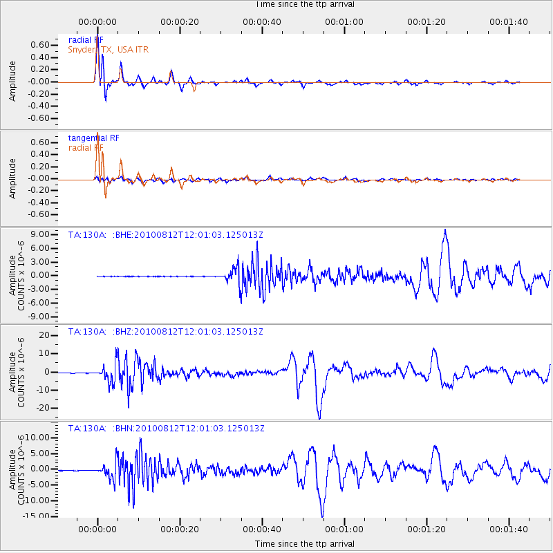
Signal To Noise
| Channel | StoN | STA | LTA |
| TA:130A: :BHZ:20100812T12:01:03.125013Z | 63.50354 | 4.9796754E-6 | 7.841572E-8 |
| TA:130A: :BHN:20100812T12:01:03.125013Z | 55.38599 | 2.4859933E-6 | 4.4884874E-8 |
| TA:130A: :BHE:20100812T12:01:03.125013Z | 37.78032 | 1.6929065E-6 | 4.4809216E-8 |
| Arrivals |
| Ps | 5.8 SECOND |
| PpPs | 15 SECOND |
| PsPs/PpSs | 21 SECOND |


