You are here: Home > Network List > TA - USArray Transportable Network (new EarthScope stations) Stations List
> Station H27A Howes, SD, USA > Earthquake Result Viewer
H27A Howes, SD, USA - Earthquake Result Viewer

| Earthquake location: |
Ecuador |
| Earthquake latitude/longitude: |
-1.3/-77.3 |
| Earthquake time(UTC): |
2010/08/12 (224) 11:54:15 GMT |
| Earthquake Depth: |
207 km |
| Earthquake Magnitude: |
6.4 MB, 7.1 MW, 7.1 MW |
| Earthquake Catalog/Contributor: |
WHDF/NEIC |
|
| Network: |
TA USArray Transportable Network (new EarthScope stations) |
| Station: |
H27A Howes, SD, USA |
| Lat/Lon: |
44.63 N/102.08 W |
| Elevation: |
748 m |
|
| Distance: |
50.7 deg |
| Az: |
337.273 deg |
| Baz: |
147.25 deg |
| Ray Param: |
0.06710925 |
| Estimated Moho Depth: |
45.0 km |
| Estimated Crust Vp/Vs: |
1.85 |
| Assumed Crust Vp: |
6.242 km/s |
| Estimated Crust Vs: |
3.383 km/s |
| Estimated Crust Poisson's Ratio: |
0.29 |
|
| Radial Match: |
97.66405 % |
| Radial Bump: |
366 |
| Transverse Match: |
89.31456 % |
| Transverse Bump: |
400 |
| SOD ConfigId: |
319893 |
| Insert Time: |
2011-01-05 20:42:26.186 +0000 |
| GWidth: |
2.5 |
| Max Bumps: |
400 |
| Tol: |
0.001 |
|
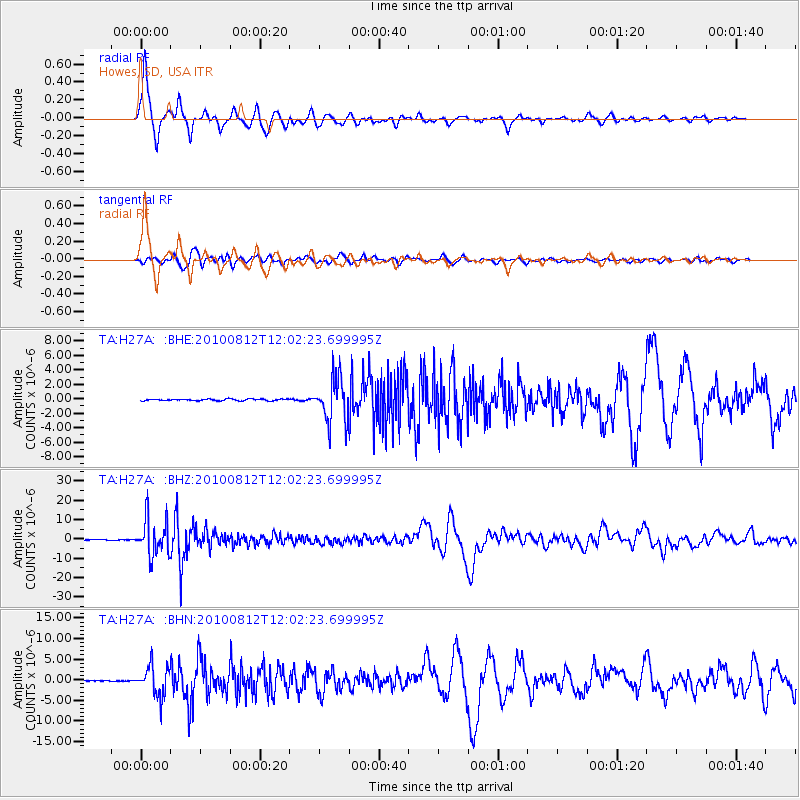
Signal To Noise
| Channel | StoN | STA | LTA |
| TA:H27A: :BHZ:20100812T12:02:23.699995Z | 142.99725 | 9.426396E-6 | 6.592011E-8 |
| TA:H27A: :BHN:20100812T12:02:23.699995Z | 31.33995 | 3.5608455E-6 | 1.1362001E-7 |
| TA:H27A: :BHE:20100812T12:02:23.699995Z | 25.54477 | 3.0283286E-6 | 1.18549856E-7 |
| Arrivals |
| Ps | 6.4 SECOND |
| PpPs | 19 SECOND |
| PsPs/PpSs | 26 SECOND |


