You are here: Home > Network List > AV - Alaska Volcano Observatory Stations List
> Station MTBL Table Top, Makushin Volcano, Alaska > Earthquake Result Viewer
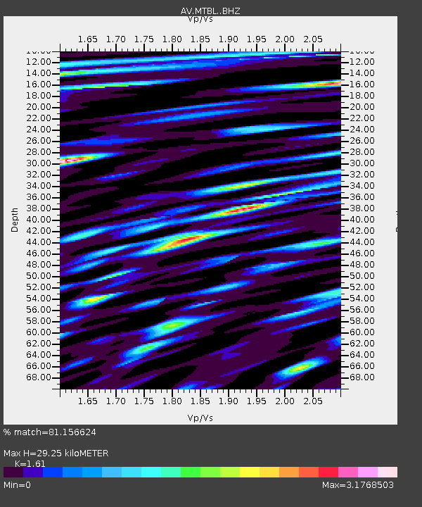
MTBL Table Top, Makushin Volcano, Alaska - Earthquake Result Viewer
| Earthquake location: |
Mindanao, Philippines |
| Earthquake latitude/longitude: |
8.4/126.7 |
| Earthquake time(UTC): |
2023/12/03 (337) 10:35:57 GMT |
| Earthquake Depth: |
56 km |
| Earthquake Magnitude: |
6.6 mww |
| Earthquake Catalog/Contributor: |
NEIC PDE/us |
|
| Network: |
AV Alaska Volcano Observatory |
| Station: |
MTBL Table Top, Makushin Volcano, Alaska |
| Lat/Lon: |
53.97 N/166.68 W |
| Elevation: |
810 m |
|
| Distance: |
69.5 deg |
| Az: |
35.367 deg |
| Baz: |
255.739 deg |
| Ray Param: |
0.05547635 |
| Estimated Moho Depth: |
29.25 km |
| Estimated Crust Vp/Vs: |
1.61 |
| Assumed Crust Vp: |
3.943 km/s |
| Estimated Crust Vs: |
2.449 km/s |
| Estimated Crust Poisson's Ratio: |
0.19 |
|
| Radial Match: |
81.156624 % |
| Radial Bump: |
400 |
| Transverse Match: |
79.28929 % |
| Transverse Bump: |
400 |
| SOD ConfigId: |
33232451 |
| Insert Time: |
2023-12-17 10:44:42.210 +0000 |
| GWidth: |
2.5 |
| Max Bumps: |
400 |
| Tol: |
0.001 |
|

Signal To Noise
| Channel | StoN | STA | LTA |
| AV:MTBL: :BHZ:20231203T10:46:29.240024Z | 3.6926484 | 2.0868401E-6 | 5.6513375E-7 |
| AV:MTBL: :BHN:20231203T10:46:29.240024Z | 1.0580022 | 1.2634513E-6 | 1.1941859E-6 |
| AV:MTBL: :BHE:20231203T10:46:29.240024Z | 1.4617265 | 1.8207949E-6 | 1.2456467E-6 |
| Arrivals |
| Ps | 4.6 SECOND |
| PpPs | 19 SECOND |
| PsPs/PpSs | 24 SECOND |


