You are here: Home > Network List > TA - USArray Transportable Network (new EarthScope stations) Stations List
> Station G26A Maurine, SD, USA > Earthquake Result Viewer
G26A Maurine, SD, USA - Earthquake Result Viewer

| Earthquake location: |
Ecuador |
| Earthquake latitude/longitude: |
-1.3/-77.3 |
| Earthquake time(UTC): |
2010/08/12 (224) 11:54:15 GMT |
| Earthquake Depth: |
207 km |
| Earthquake Magnitude: |
6.4 MB, 7.1 MW, 7.1 MW |
| Earthquake Catalog/Contributor: |
WHDF/NEIC |
|
| Network: |
TA USArray Transportable Network (new EarthScope stations) |
| Station: |
G26A Maurine, SD, USA |
| Lat/Lon: |
45.29 N/102.60 W |
| Elevation: |
833 m |
|
| Distance: |
51.5 deg |
| Az: |
337.335 deg |
| Baz: |
146.922 deg |
| Ray Param: |
0.06662745 |
| Estimated Moho Depth: |
14.75 km |
| Estimated Crust Vp/Vs: |
1.82 |
| Assumed Crust Vp: |
6.242 km/s |
| Estimated Crust Vs: |
3.439 km/s |
| Estimated Crust Poisson's Ratio: |
0.28 |
|
| Radial Match: |
97.56406 % |
| Radial Bump: |
299 |
| Transverse Match: |
90.37483 % |
| Transverse Bump: |
400 |
| SOD ConfigId: |
319893 |
| Insert Time: |
2011-01-05 20:43:12.297 +0000 |
| GWidth: |
2.5 |
| Max Bumps: |
400 |
| Tol: |
0.001 |
|
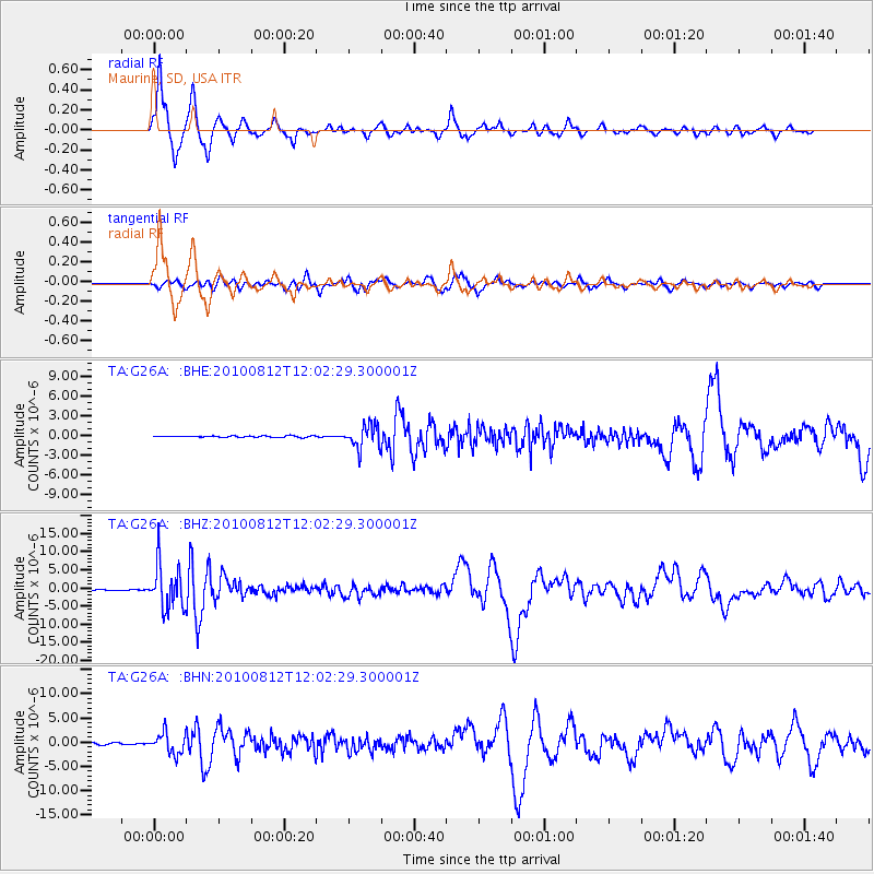
Signal To Noise
| Channel | StoN | STA | LTA |
| TA:G26A: :BHZ:20100812T12:02:29.300001Z | 102.91503 | 5.9423114E-6 | 5.7739978E-8 |
| TA:G26A: :BHN:20100812T12:02:29.300001Z | 11.736197 | 2.1331625E-6 | 1.8175926E-7 |
| TA:G26A: :BHE:20100812T12:02:29.300001Z | 16.713844 | 1.7897983E-6 | 1.0708478E-7 |
| Arrivals |
| Ps | 2.0 SECOND |
| PpPs | 6.3 SECOND |
| PsPs/PpSs | 8.3 SECOND |


