You are here: Home > Network List > G - GEOSCOPE Stations List
> Station ATD Arta Cave - Arta, Republic of Djibouti > Earthquake Result Viewer
ATD Arta Cave - Arta, Republic of Djibouti - Earthquake Result Viewer
| Earthquake location: |
Mindanao, Philippines |
| Earthquake latitude/longitude: |
8.4/126.7 |
| Earthquake time(UTC): |
2023/12/03 (337) 10:35:57 GMT |
| Earthquake Depth: |
56 km |
| Earthquake Magnitude: |
6.6 mww |
| Earthquake Catalog/Contributor: |
NEIC PDE/us |
|
| Network: |
G GEOSCOPE |
| Station: |
ATD Arta Cave - Arta, Republic of Djibouti |
| Lat/Lon: |
11.53 N/42.85 E |
| Elevation: |
610 m |
|
| Distance: |
82.4 deg |
| Az: |
280.534 deg |
| Baz: |
82.924 deg |
| Ray Param: |
0.04681975 |
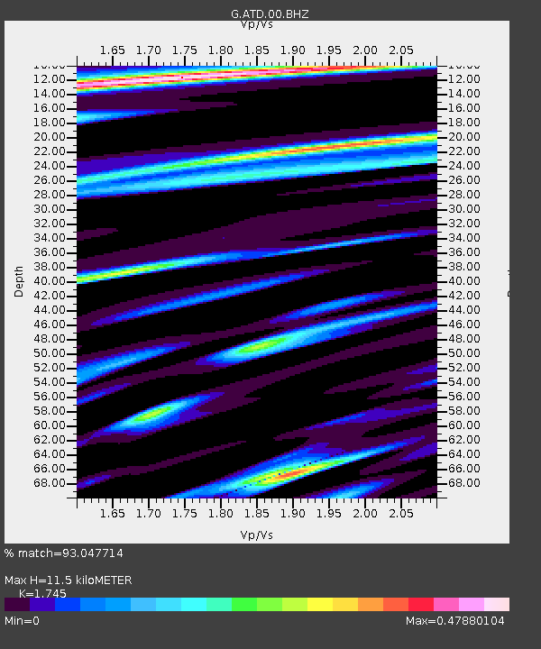
| Estimated Moho Depth: |
11.5 km |
| Estimated Crust Vp/Vs: |
1.75 |
| Assumed Crust Vp: |
6.375 km/s |
| Estimated Crust Vs: |
3.653 km/s |
| Estimated Crust Poisson's Ratio: |
0.26 |
|
| Radial Match: |
93.047714 % |
| Radial Bump: |
400 |
| Transverse Match: |
76.44596 % |
| Transverse Bump: |
400 |
| SOD ConfigId: |
33232451 |
| Insert Time: |
2023-12-17 10:47:13.882 +0000 |
| GWidth: |
2.5 |
| Max Bumps: |
400 |
| Tol: |
0.001 |
|
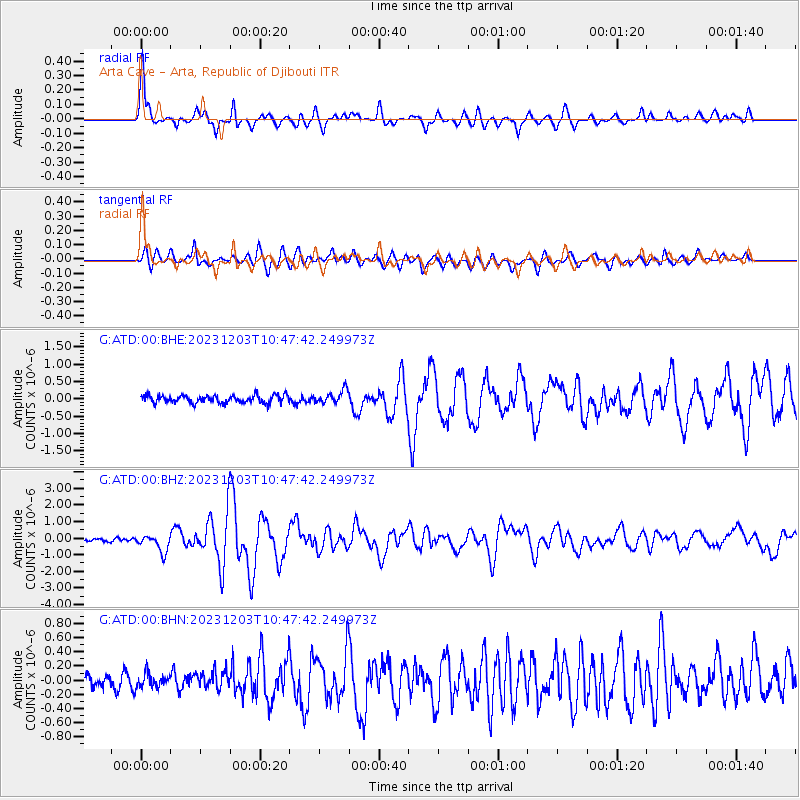
Signal To Noise
| Channel | StoN | STA | LTA |
| G:ATD:00:BHZ:20231203T10:47:42.249973Z | 5.4937334 | 5.161569E-7 | 9.395376E-8 |
| G:ATD:00:BHN:20231203T10:47:42.249973Z | 0.86942637 | 9.928201E-8 | 1.1419255E-7 |
| G:ATD:00:BHE:20231203T10:47:42.249973Z | 1.704204 | 1.9181883E-7 | 1.12556265E-7 |
| Arrivals |
| Ps | 1.4 SECOND |
| PpPs | 4.8 SECOND |
| PsPs/PpSs | 6.2 SECOND |


