You are here: Home > Network List > KO - Kandilli Observatory Digital Broadband Seismic Network Stations List
> Station MDUB Mudurnu-Bolu-Turkey > Earthquake Result Viewer
MDUB Mudurnu-Bolu-Turkey - Earthquake Result Viewer
| Earthquake location: |
Mindanao, Philippines |
| Earthquake latitude/longitude: |
8.4/126.7 |
| Earthquake time(UTC): |
2023/12/03 (337) 10:35:57 GMT |
| Earthquake Depth: |
56 km |
| Earthquake Magnitude: |
6.6 mww |
| Earthquake Catalog/Contributor: |
NEIC PDE/us |
|
| Network: |
KO Kandilli Observatory Digital Broadband Seismic Network |
| Station: |
MDUB Mudurnu-Bolu-Turkey |
| Lat/Lon: |
40.47 N/31.20 E |
| Elevation: |
1109 m |
|
| Distance: |
88.8 deg |
| Az: |
310.578 deg |
| Baz: |
80.04 deg |
| Ray Param: |
0.04225537 |
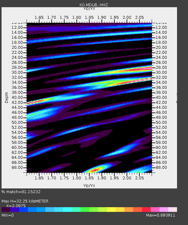
| Estimated Moho Depth: |
32.25 km |
| Estimated Crust Vp/Vs: |
2.10 |
| Assumed Crust Vp: |
6.287 km/s |
| Estimated Crust Vs: |
2.998 km/s |
| Estimated Crust Poisson's Ratio: |
0.35 |
|
| Radial Match: |
81.15232 % |
| Radial Bump: |
400 |
| Transverse Match: |
81.12035 % |
| Transverse Bump: |
400 |
| SOD ConfigId: |
33232451 |
| Insert Time: |
2023-12-17 10:49:42.720 +0000 |
| GWidth: |
2.5 |
| Max Bumps: |
400 |
| Tol: |
0.001 |
|

Signal To Noise
| Channel | StoN | STA | LTA |
| KO:MDUB: :HHZ:20231203T10:48:13.730014Z | 5.229259 | 4.2581115E-7 | 8.142858E-8 |
| KO:MDUB: :HHN:20231203T10:48:13.730014Z | 0.99830896 | 2.0353226E-9 | 2.0387703E-9 |
| KO:MDUB: :HHE:20231203T10:48:13.730014Z | 1.2230482 | 1.7353689E-7 | 1.4188883E-7 |
| Arrivals |
| Ps | 5.7 SECOND |
| PpPs | 16 SECOND |
| PsPs/PpSs | 21 SECOND |


