You are here: Home > Network List > TA - USArray Transportable Network (new EarthScope stations) Stations List
> Station D28A Regan, ND, USA > Earthquake Result Viewer
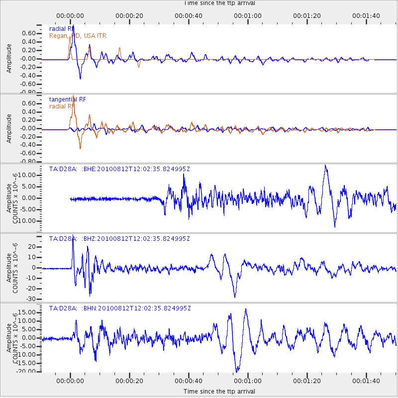
D28A Regan, ND, USA - Earthquake Result Viewer

| Earthquake location: |
Ecuador |
| Earthquake latitude/longitude: |
-1.3/-77.3 |
| Earthquake time(UTC): |
2010/08/12 (224) 11:54:15 GMT |
| Earthquake Depth: |
207 km |
| Earthquake Magnitude: |
6.4 MB, 7.1 MW, 7.1 MW |
| Earthquake Catalog/Contributor: |
WHDF/NEIC |
|
| Network: |
TA USArray Transportable Network (new EarthScope stations) |
| Station: |
D28A Regan, ND, USA |
| Lat/Lon: |
47.19 N/100.57 W |
| Elevation: |
621 m |
|
| Distance: |
52.4 deg |
| Az: |
340.121 deg |
| Baz: |
150.101 deg |
| Ray Param: |
0.06604869 |
| Estimated Moho Depth: |
17.0 km |
| Estimated Crust Vp/Vs: |
1.75 |
| Assumed Crust Vp: |
6.438 km/s |
| Estimated Crust Vs: |
3.668 km/s |
| Estimated Crust Poisson's Ratio: |
0.26 |
|
| Radial Match: |
98.572876 % |
| Radial Bump: |
244 |
| Transverse Match: |
87.51253 % |
| Transverse Bump: |
400 |
| SOD ConfigId: |
319893 |
| Insert Time: |
2011-01-05 20:44:40.690 +0000 |
| GWidth: |
2.5 |
| Max Bumps: |
400 |
| Tol: |
0.001 |
|
Signal To Noise
| Channel | StoN | STA | LTA |
| TA:D28A: :BHZ:20100812T12:02:35.824995Z | 44.05911 | 9.711667E-6 | 2.2042359E-7 |
| TA:D28A: :BHN:20100812T12:02:35.824995Z | 9.623427 | 4.335339E-6 | 4.5049842E-7 |
| TA:D28A: :BHE:20100812T12:02:35.824995Z | 9.154201 | 2.782569E-6 | 3.0396637E-7 |
| Arrivals |
| Ps | 2.1 SECOND |
| PpPs | 6.9 SECOND |
| PsPs/PpSs | 9.0 SECOND |


