You are here: Home > Network List > TA - USArray Transportable Network (new EarthScope stations) Stations List
> Station B27A Peters Farms, Glenburn, ND, USA > Earthquake Result Viewer
B27A Peters Farms, Glenburn, ND, USA - Earthquake Result Viewer
| Earthquake location: |
Ecuador |
| Earthquake latitude/longitude: |
-1.3/-77.3 |
| Earthquake time(UTC): |
2010/08/12 (224) 11:54:15 GMT |
| Earthquake Depth: |
207 km |
| Earthquake Magnitude: |
6.4 MB, 7.1 MW, 7.1 MW |
| Earthquake Catalog/Contributor: |
WHDF/NEIC |
|
| Network: |
TA USArray Transportable Network (new EarthScope stations) |
| Station: |
B27A Peters Farms, Glenburn, ND, USA |
| Lat/Lon: |
48.40 N/101.26 W |
| Elevation: |
492 m |
|
| Distance: |
53.7 deg |
| Az: |
340.377 deg |
| Baz: |
149.745 deg |
| Ray Param: |
0.06523279 |
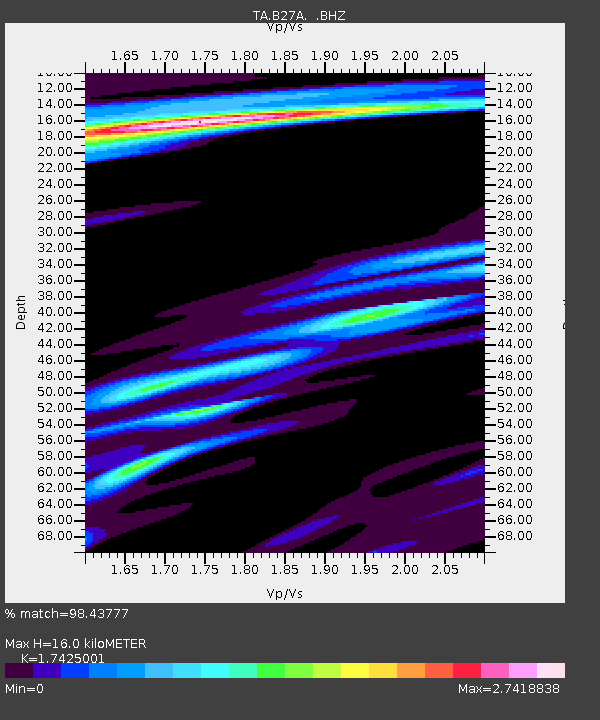
| Estimated Moho Depth: |
16.0 km |
| Estimated Crust Vp/Vs: |
1.74 |
| Assumed Crust Vp: |
6.438 km/s |
| Estimated Crust Vs: |
3.694 km/s |
| Estimated Crust Poisson's Ratio: |
0.25 |
|
| Radial Match: |
98.43777 % |
| Radial Bump: |
308 |
| Transverse Match: |
90.97304 % |
| Transverse Bump: |
400 |
| SOD ConfigId: |
319893 |
| Insert Time: |
2011-01-05 20:44:45.568 +0000 |
| GWidth: |
2.5 |
| Max Bumps: |
400 |
| Tol: |
0.001 |
|

Signal To Noise
| Channel | StoN | STA | LTA |
| TA:B27A: :BHZ:20100812T12:02:45.150007Z | 75.64968 | 7.837543E-6 | 1.0360313E-7 |
| TA:B27A: :BHN:20100812T12:02:45.150007Z | 19.168427 | 3.3963888E-6 | 1.7718664E-7 |
| TA:B27A: :BHE:20100812T12:02:45.150007Z | 9.325278 | 2.1071803E-6 | 2.2596436E-7 |
| Arrivals |
| Ps | 1.9 SECOND |
| PpPs | 6.5 SECOND |
| PsPs/PpSs | 8.4 SECOND |


