You are here: Home > Network List > TA - USArray Transportable Network (new EarthScope stations) Stations List
> Station A27A Ledoux Ranch, Antler, ND, USA > Earthquake Result Viewer
A27A Ledoux Ranch, Antler, ND, USA - Earthquake Result Viewer
| Earthquake location: |
Ecuador |
| Earthquake latitude/longitude: |
-1.3/-77.3 |
| Earthquake time(UTC): |
2010/08/12 (224) 11:54:15 GMT |
| Earthquake Depth: |
207 km |
| Earthquake Magnitude: |
6.4 MB, 7.1 MW, 7.1 MW |
| Earthquake Catalog/Contributor: |
WHDF/NEIC |
|
| Network: |
TA USArray Transportable Network (new EarthScope stations) |
| Station: |
A27A Ledoux Ranch, Antler, ND, USA |
| Lat/Lon: |
48.95 N/101.24 W |
| Elevation: |
466 m |
|
| Distance: |
54.1 deg |
| Az: |
340.732 deg |
| Baz: |
149.968 deg |
| Ray Param: |
0.0649244 |
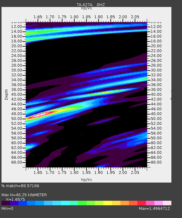
| Estimated Moho Depth: |
48.25 km |
| Estimated Crust Vp/Vs: |
1.66 |
| Assumed Crust Vp: |
6.438 km/s |
| Estimated Crust Vs: |
3.884 km/s |
| Estimated Crust Poisson's Ratio: |
0.21 |
|
| Radial Match: |
98.57186 % |
| Radial Bump: |
321 |
| Transverse Match: |
91.81748 % |
| Transverse Bump: |
400 |
| SOD ConfigId: |
319893 |
| Insert Time: |
2011-01-05 20:45:09.558 +0000 |
| GWidth: |
2.5 |
| Max Bumps: |
400 |
| Tol: |
0.001 |
|

Signal To Noise
| Channel | StoN | STA | LTA |
| TA:A27A: :BHZ:20100812T12:02:48.525007Z | 103.34872 | 1.1144261E-5 | 1.0783164E-7 |
| TA:A27A: :BHN:20100812T12:02:48.525007Z | 43.051903 | 5.793223E-6 | 1.3456368E-7 |
| TA:A27A: :BHE:20100812T12:02:48.525007Z | 18.034925 | 3.3259064E-6 | 1.8441474E-7 |
| Arrivals |
| Ps | 5.2 SECOND |
| PpPs | 19 SECOND |
| PsPs/PpSs | 24 SECOND |


