You are here: Home > Network List > TA - USArray Transportable Network (new EarthScope stations) Stations List
> Station A28A Rude Farm, Bottineau, ND, USA > Earthquake Result Viewer
A28A Rude Farm, Bottineau, ND, USA - Earthquake Result Viewer
| Earthquake location: |
Ecuador |
| Earthquake latitude/longitude: |
-1.3/-77.3 |
| Earthquake time(UTC): |
2010/08/12 (224) 11:54:15 GMT |
| Earthquake Depth: |
207 km |
| Earthquake Magnitude: |
6.4 MB, 7.1 MW, 7.1 MW |
| Earthquake Catalog/Contributor: |
WHDF/NEIC |
|
| Network: |
TA USArray Transportable Network (new EarthScope stations) |
| Station: |
A28A Rude Farm, Bottineau, ND, USA |
| Lat/Lon: |
48.91 N/100.27 W |
| Elevation: |
692 m |
|
| Distance: |
53.8 deg |
| Az: |
341.397 deg |
| Baz: |
151.092 deg |
| Ray Param: |
0.065157354 |
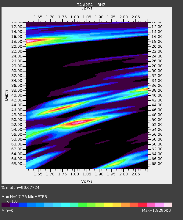
| Estimated Moho Depth: |
17.75 km |
| Estimated Crust Vp/Vs: |
1.60 |
| Assumed Crust Vp: |
6.438 km/s |
| Estimated Crust Vs: |
4.023 km/s |
| Estimated Crust Poisson's Ratio: |
0.18 |
|
| Radial Match: |
96.07724 % |
| Radial Bump: |
400 |
| Transverse Match: |
91.285484 % |
| Transverse Bump: |
400 |
| SOD ConfigId: |
319893 |
| Insert Time: |
2011-01-05 20:45:22.101 +0000 |
| GWidth: |
2.5 |
| Max Bumps: |
400 |
| Tol: |
0.001 |
|
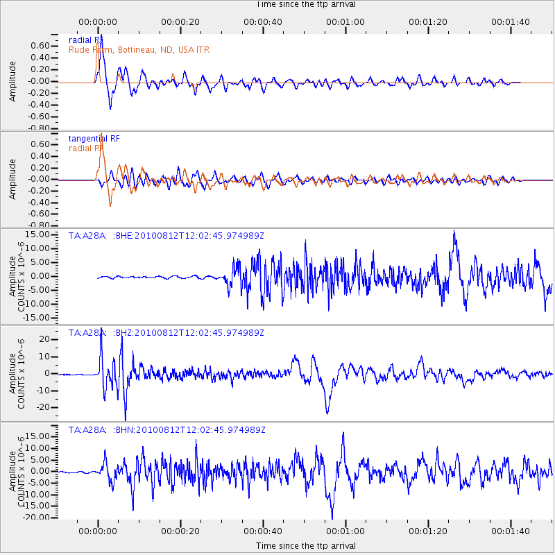
Signal To Noise
| Channel | StoN | STA | LTA |
| TA:A28A: :BHZ:20100812T12:02:45.974989Z | 76.909454 | 9.027394E-6 | 1.1737692E-7 |
| TA:A28A: :BHN:20100812T12:02:45.974989Z | 10.149611 | 3.7760954E-6 | 3.7204333E-7 |
| TA:A28A: :BHE:20100812T12:02:45.974989Z | 10.365772 | 3.368697E-6 | 3.2498275E-7 |
| Arrivals |
| Ps | 1.8 SECOND |
| PpPs | 6.8 SECOND |
| PsPs/PpSs | 8.5 SECOND |


