You are here: Home > Network List > TA - USArray Transportable Network (new EarthScope stations) Stations List
> Station E28A Huff, ND, USA > Earthquake Result Viewer
E28A Huff, ND, USA - Earthquake Result Viewer
| Earthquake location: |
Ecuador |
| Earthquake latitude/longitude: |
-1.3/-77.3 |
| Earthquake time(UTC): |
2010/08/12 (224) 11:54:15 GMT |
| Earthquake Depth: |
207 km |
| Earthquake Magnitude: |
6.4 MB, 7.1 MW, 7.1 MW |
| Earthquake Catalog/Contributor: |
WHDF/NEIC |
|
| Network: |
TA USArray Transportable Network (new EarthScope stations) |
| Station: |
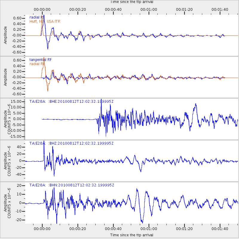
E28A Huff, ND, USA |
| Lat/Lon: |
46.57 N/100.69 W |
| Elevation: |
579 m |
|
| Distance: |
51.9 deg |
| Az: |
339.635 deg |
| Baz: |
149.712 deg |
| Ray Param: |
0.06637356 |
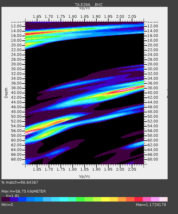
| Estimated Moho Depth: |
56.75 km |
| Estimated Crust Vp/Vs: |
1.61 |
| Assumed Crust Vp: |
6.438 km/s |
| Estimated Crust Vs: |
3.998 km/s |
| Estimated Crust Poisson's Ratio: |
0.19 |
|
| Radial Match: |
98.64367 % |
| Radial Bump: |
296 |
| Transverse Match: |
94.349045 % |
| Transverse Bump: |
400 |
| SOD ConfigId: |
319893 |
| Insert Time: |
2011-01-05 20:45:33.901 +0000 |
| GWidth: |
2.5 |
| Max Bumps: |
400 |
| Tol: |
0.001 |
|
Signal To Noise
| Channel | StoN | STA | LTA |
| TA:E28A: :BHZ:20100812T12:02:32.199995Z | 169.36313 | 1.5055796E-5 | 8.889654E-8 |
| TA:E28A: :BHN:20100812T12:02:32.199995Z | 34.042854 | 5.519849E-6 | 1.6214412E-7 |
| TA:E28A: :BHE:20100812T12:02:32.199995Z | 36.030823 | 4.582347E-6 | 1.2717854E-7 |
| Arrivals |
| Ps | 5.7 SECOND |
| PpPs | 22 SECOND |
| PsPs/PpSs | 27 SECOND |


