You are here: Home > Network List > TA - USArray Transportable Network (new EarthScope stations) Stations List
> Station F28A McLaughlin, SD, USA > Earthquake Result Viewer
F28A McLaughlin, SD, USA - Earthquake Result Viewer
| Earthquake location: |
Ecuador |
| Earthquake latitude/longitude: |
-1.3/-77.3 |
| Earthquake time(UTC): |
2010/08/12 (224) 11:54:15 GMT |
| Earthquake Depth: |
207 km |
| Earthquake Magnitude: |
6.4 MB, 7.1 MW, 7.1 MW |
| Earthquake Catalog/Contributor: |
WHDF/NEIC |
|
| Network: |
TA USArray Transportable Network (new EarthScope stations) |
| Station: |
F28A McLaughlin, SD, USA |
| Lat/Lon: |
45.85 N/100.80 W |
| Elevation: |
633 m |
|
| Distance: |
51.3 deg |
| Az: |
339.083 deg |
| Baz: |
149.292 deg |
| Ray Param: |
0.06675117 |
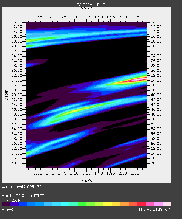
| Estimated Moho Depth: |
33.0 km |
| Estimated Crust Vp/Vs: |
2.09 |
| Assumed Crust Vp: |
6.53 km/s |
| Estimated Crust Vs: |
3.125 km/s |
| Estimated Crust Poisson's Ratio: |
0.35 |
|
| Radial Match: |
97.909134 % |
| Radial Bump: |
343 |
| Transverse Match: |
87.34148 % |
| Transverse Bump: |
400 |
| SOD ConfigId: |
319893 |
| Insert Time: |
2011-01-05 20:46:19.644 +0000 |
| GWidth: |
2.5 |
| Max Bumps: |
400 |
| Tol: |
0.001 |
|
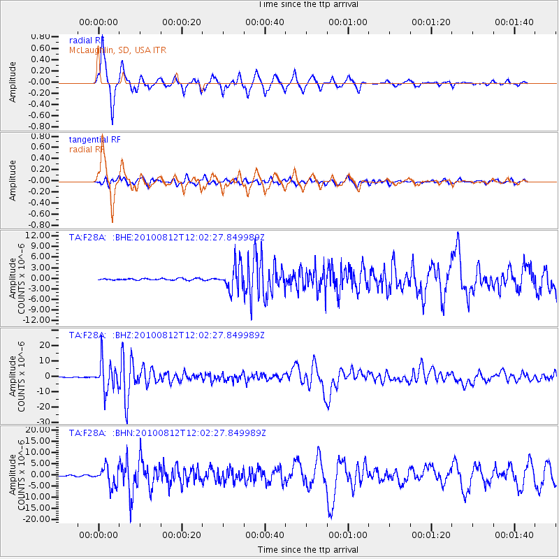
Signal To Noise
| Channel | StoN | STA | LTA |
| TA:F28A: :BHZ:20100812T12:02:27.849989Z | 86.58341 | 9.590711E-6 | 1.1076845E-7 |
| TA:F28A: :BHN:20100812T12:02:27.849989Z | 24.507578 | 4.3680925E-6 | 1.7823436E-7 |
| TA:F28A: :BHE:20100812T12:02:27.849989Z | 16.414589 | 3.6628508E-6 | 2.2314605E-7 |
| Arrivals |
| Ps | 5.8 SECOND |
| PpPs | 15 SECOND |
| PsPs/PpSs | 21 SECOND |


