You are here: Home > Network List > AV - Alaska Volcano Observatory Stations List
> Station MAPS Pakushin Southeast, Makushin Volcano, Alaska > Earthquake Result Viewer
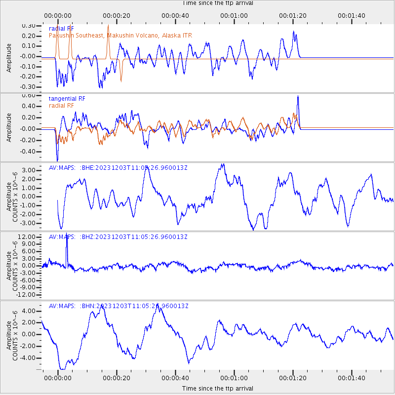
MAPS Pakushin Southeast, Makushin Volcano, Alaska - Earthquake Result Viewer
*The percent match for this event was below the threshold and hence no stack was calculated.
| Earthquake location: |
Mindanao, Philippines |
| Earthquake latitude/longitude: |
8.5/126.9 |
| Earthquake time(UTC): |
2023/12/03 (337) 10:54:56 GMT |
| Earthquake Depth: |
46 km |
| Earthquake Magnitude: |
5.6 Mww |
| Earthquake Catalog/Contributor: |
NEIC PDE/us |
|
| Network: |
AV Alaska Volcano Observatory |
| Station: |
MAPS Pakushin Southeast, Makushin Volcano, Alaska |
| Lat/Lon: |
53.81 N/166.94 W |
| Elevation: |
333 m |
|
| Distance: |
69.2 deg |
| Az: |
35.489 deg |
| Baz: |
255.503 deg |
| Ray Param: |
$rayparam |
*The percent match for this event was below the threshold and hence was not used in the summary stack. |
|
| Radial Match: |
54.994286 % |
| Radial Bump: |
389 |
| Transverse Match: |
34.01577 % |
| Transverse Bump: |
308 |
| SOD ConfigId: |
33232451 |
| Insert Time: |
2023-12-17 11:09:32.371 +0000 |
| GWidth: |
2.5 |
| Max Bumps: |
400 |
| Tol: |
0.001 |
|
Signal To Noise
| Channel | StoN | STA | LTA |
| AV:MAPS: :BHZ:20231203T11:05:26.960013Z | 4.1536255 | 3.6296044E-6 | 8.7384007E-7 |
| AV:MAPS: :BHN:20231203T11:05:26.960013Z | 2.0170498 | 5.2843548E-6 | 2.6198434E-6 |
| AV:MAPS: :BHE:20231203T11:05:26.960013Z | 1.6080194 | 2.114622E-6 | 1.3150476E-6 |
| Arrivals |
| Ps | |
| PpPs | |
| PsPs/PpSs | |


