You are here: Home > Network List > TA - USArray Transportable Network (new EarthScope stations) Stations List
> Station J30A Dallas, SD, USA > Earthquake Result Viewer
J30A Dallas, SD, USA - Earthquake Result Viewer

| Earthquake location: |
Ecuador |
| Earthquake latitude/longitude: |
-1.3/-77.3 |
| Earthquake time(UTC): |
2010/08/12 (224) 11:54:15 GMT |
| Earthquake Depth: |
207 km |
| Earthquake Magnitude: |
6.4 MB, 7.1 MW, 7.1 MW |
| Earthquake Catalog/Contributor: |
WHDF/NEIC |
|
| Network: |
TA USArray Transportable Network (new EarthScope stations) |
| Station: |
J30A Dallas, SD, USA |
| Lat/Lon: |
43.32 N/99.49 W |
| Elevation: |
608 m |
|
| Distance: |
48.7 deg |
| Az: |
338.466 deg |
| Baz: |
149.811 deg |
| Ray Param: |
0.06844244 |
| Estimated Moho Depth: |
52.0 km |
| Estimated Crust Vp/Vs: |
2.03 |
| Assumed Crust Vp: |
6.53 km/s |
| Estimated Crust Vs: |
3.217 km/s |
| Estimated Crust Poisson's Ratio: |
0.34 |
|
| Radial Match: |
92.756256 % |
| Radial Bump: |
400 |
| Transverse Match: |
83.57562 % |
| Transverse Bump: |
400 |
| SOD ConfigId: |
319893 |
| Insert Time: |
2011-01-05 20:47:42.053 +0000 |
| GWidth: |
2.5 |
| Max Bumps: |
400 |
| Tol: |
0.001 |
|
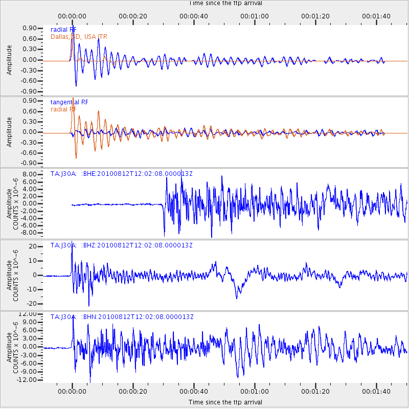
Signal To Noise
| Channel | StoN | STA | LTA |
| TA:J30A: :BHZ:20100812T12:02:08.000013Z | 139.48853 | 7.404183E-6 | 5.3080946E-8 |
| TA:J30A: :BHN:20100812T12:02:08.000013Z | 39.773636 | 3.4401664E-6 | 8.649364E-8 |
| TA:J30A: :BHE:20100812T12:02:08.000013Z | 29.029217 | 3.0606402E-6 | 1.05433095E-7 |
| Arrivals |
| Ps | 8.6 SECOND |
| PpPs | 23 SECOND |
| PsPs/PpSs | 32 SECOND |


