You are here: Home > Network List > TA - USArray Transportable Network (new EarthScope stations) Stations List
> Station K04D Chiloquin, OR, USA > Earthquake Result Viewer
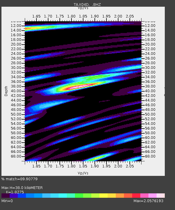
K04D Chiloquin, OR, USA - Earthquake Result Viewer
| Earthquake location: |
Ecuador |
| Earthquake latitude/longitude: |
-1.3/-77.3 |
| Earthquake time(UTC): |
2010/08/12 (224) 11:54:15 GMT |
| Earthquake Depth: |
207 km |
| Earthquake Magnitude: |
6.4 MB, 7.1 MW, 7.1 MW |
| Earthquake Catalog/Contributor: |
WHDF/NEIC |
|
| Network: |
TA USArray Transportable Network (new EarthScope stations) |
| Station: |
K04D Chiloquin, OR, USA |
| Lat/Lon: |
42.62 N/121.75 W |
| Elevation: |
1315 m |
|
| Distance: |
59.2 deg |
| Az: |
323.011 deg |
| Baz: |
125.413 deg |
| Ray Param: |
0.061668437 |
| Estimated Moho Depth: |
38.0 km |
| Estimated Crust Vp/Vs: |
1.83 |
| Assumed Crust Vp: |
6.597 km/s |
| Estimated Crust Vs: |
3.61 km/s |
| Estimated Crust Poisson's Ratio: |
0.29 |
|
| Radial Match: |
89.90779 % |
| Radial Bump: |
400 |
| Transverse Match: |
83.3625 % |
| Transverse Bump: |
400 |
| SOD ConfigId: |
319893 |
| Insert Time: |
2011-01-05 20:48:10.738 +0000 |
| GWidth: |
2.5 |
| Max Bumps: |
400 |
| Tol: |
0.001 |
|

Signal To Noise
| Channel | StoN | STA | LTA |
| TA:K04D: :BHZ:20100812T12:03:24.074995Z | 46.26873 | 4.8416637E-6 | 1.0464225E-7 |
| TA:K04D: :BHN:20100812T12:03:24.074995Z | 7.9628916 | 1.5151344E-6 | 1.9027439E-7 |
| TA:K04D: :BHE:20100812T12:03:24.074995Z | 9.018377 | 1.7192654E-6 | 1.9064021E-7 |
| Arrivals |
| Ps | 5.0 SECOND |
| PpPs | 16 SECOND |
| PsPs/PpSs | 21 SECOND |


