You are here: Home > Network List > TA - USArray Transportable Network (new EarthScope stations) Stations List
> Station U34A Anderson Ranch, Garber, OK, USA > Earthquake Result Viewer
U34A Anderson Ranch, Garber, OK, USA - Earthquake Result Viewer
| Earthquake location: |
Ecuador |
| Earthquake latitude/longitude: |
-1.3/-77.3 |
| Earthquake time(UTC): |
2010/08/12 (224) 11:54:15 GMT |
| Earthquake Depth: |
207 km |
| Earthquake Magnitude: |
6.4 MB, 7.1 MW, 7.1 MW |
| Earthquake Catalog/Contributor: |
WHDF/NEIC |
|
| Network: |
TA USArray Transportable Network (new EarthScope stations) |
| Station: |
U34A Anderson Ranch, Garber, OK, USA |
| Lat/Lon: |
36.44 N/97.54 W |
| Elevation: |
345 m |
|
| Distance: |
42.0 deg |
| Az: |
335.356 deg |
| Baz: |
148.872 deg |
| Ray Param: |
0.072662525 |
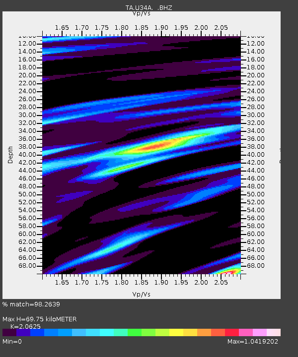
| Estimated Moho Depth: |
69.75 km |
| Estimated Crust Vp/Vs: |
2.06 |
| Assumed Crust Vp: |
6.483 km/s |
| Estimated Crust Vs: |
3.143 km/s |
| Estimated Crust Poisson's Ratio: |
0.35 |
|
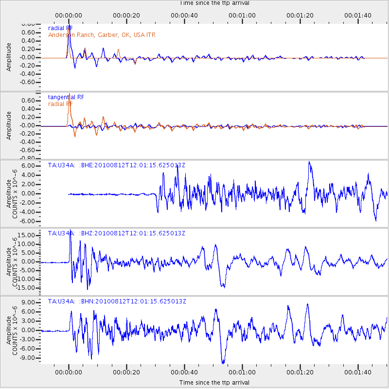
| Radial Match: |
98.2639 % |
| Radial Bump: |
283 |
| Transverse Match: |
82.47227 % |
| Transverse Bump: |
400 |
| SOD ConfigId: |
319893 |
| Insert Time: |
2011-01-05 20:48:56.850 +0000 |
| GWidth: |
2.5 |
| Max Bumps: |
400 |
| Tol: |
0.001 |
|
Signal To Noise
| Channel | StoN | STA | LTA |
| TA:U34A: :BHZ:20100812T12:01:15.625013Z | 81.10912 | 7.079241E-6 | 8.7280455E-8 |
| TA:U34A: :BHN:20100812T12:01:15.625013Z | 37.48722 | 3.2245368E-6 | 8.601696E-8 |
| TA:U34A: :BHE:20100812T12:01:15.625013Z | 29.07831 | 1.9507818E-6 | 6.708718E-8 |
| Arrivals |
| Ps | 12 SECOND |
| PpPs | 31 SECOND |
| PsPs/PpSs | 43 SECOND |


