You are here: Home > Network List > TA - USArray Transportable Network (new EarthScope stations) Stations List
> Station X33A Lawton, OK, USA > Earthquake Result Viewer
X33A Lawton, OK, USA - Earthquake Result Viewer
| Earthquake location: |
Ecuador |
| Earthquake latitude/longitude: |
-1.3/-77.3 |
| Earthquake time(UTC): |
2010/08/12 (224) 11:54:15 GMT |
| Earthquake Depth: |
207 km |
| Earthquake Magnitude: |
6.4 MB, 7.1 MW, 7.1 MW |
| Earthquake Catalog/Contributor: |
WHDF/NEIC |
|
| Network: |
TA USArray Transportable Network (new EarthScope stations) |
| Station: |
X33A Lawton, OK, USA |
| Lat/Lon: |
34.54 N/98.50 W |
| Elevation: |
346 m |
|
| Distance: |
40.8 deg |
| Az: |
332.818 deg |
| Baz: |
146.41 deg |
| Ray Param: |
0.07336385 |
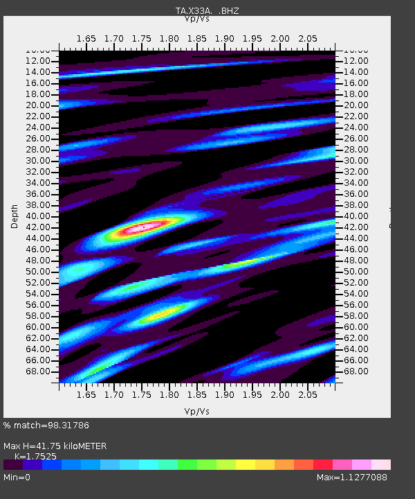
| Estimated Moho Depth: |
41.75 km |
| Estimated Crust Vp/Vs: |
1.75 |
| Assumed Crust Vp: |
6.315 km/s |
| Estimated Crust Vs: |
3.604 km/s |
| Estimated Crust Poisson's Ratio: |
0.26 |
|
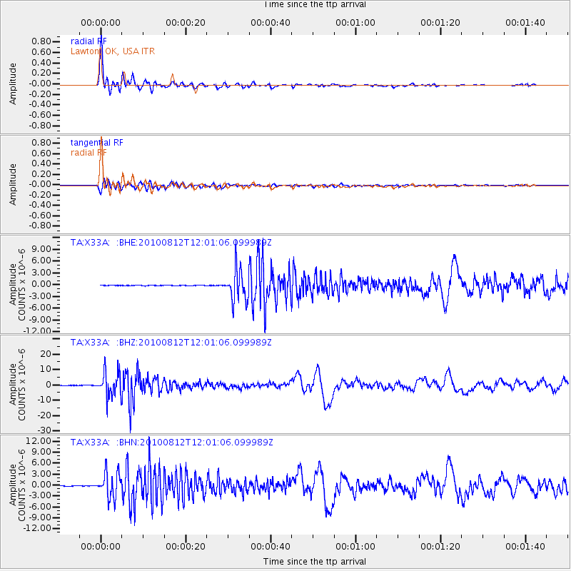
| Radial Match: |
98.31786 % |
| Radial Bump: |
400 |
| Transverse Match: |
93.14362 % |
| Transverse Bump: |
400 |
| SOD ConfigId: |
319893 |
| Insert Time: |
2011-01-05 20:49:04.757 +0000 |
| GWidth: |
2.5 |
| Max Bumps: |
400 |
| Tol: |
0.001 |
|
Signal To Noise
| Channel | StoN | STA | LTA |
| TA:X33A: :BHZ:20100812T12:01:06.099989Z | 125.888054 | 7.951499E-6 | 6.3163256E-8 |
| TA:X33A: :BHN:20100812T12:01:06.099989Z | 49.650055 | 3.48948E-6 | 7.0281494E-8 |
| TA:X33A: :BHE:20100812T12:01:06.099989Z | 59.358627 | 3.9922425E-6 | 6.7256316E-8 |
| Arrivals |
| Ps | 5.3 SECOND |
| PpPs | 17 SECOND |
| PsPs/PpSs | 22 SECOND |


