You are here: Home > Network List > TA - USArray Transportable Network (new EarthScope stations) Stations List
> Station X32A Elmer, OK, USA > Earthquake Result Viewer
X32A Elmer, OK, USA - Earthquake Result Viewer
| Earthquake location: |
Ecuador |
| Earthquake latitude/longitude: |
-1.3/-77.3 |
| Earthquake time(UTC): |
2010/08/12 (224) 11:54:15 GMT |
| Earthquake Depth: |
207 km |
| Earthquake Magnitude: |
6.4 MB, 7.1 MW, 7.1 MW |
| Earthquake Catalog/Contributor: |
WHDF/NEIC |
|
| Network: |
TA USArray Transportable Network (new EarthScope stations) |
| Station: |
X32A Elmer, OK, USA |
| Lat/Lon: |
34.42 N/99.29 W |
| Elevation: |
401 m |
|
| Distance: |
41.1 deg |
| Az: |
331.897 deg |
| Baz: |
145.271 deg |
| Ray Param: |
0.073213145 |
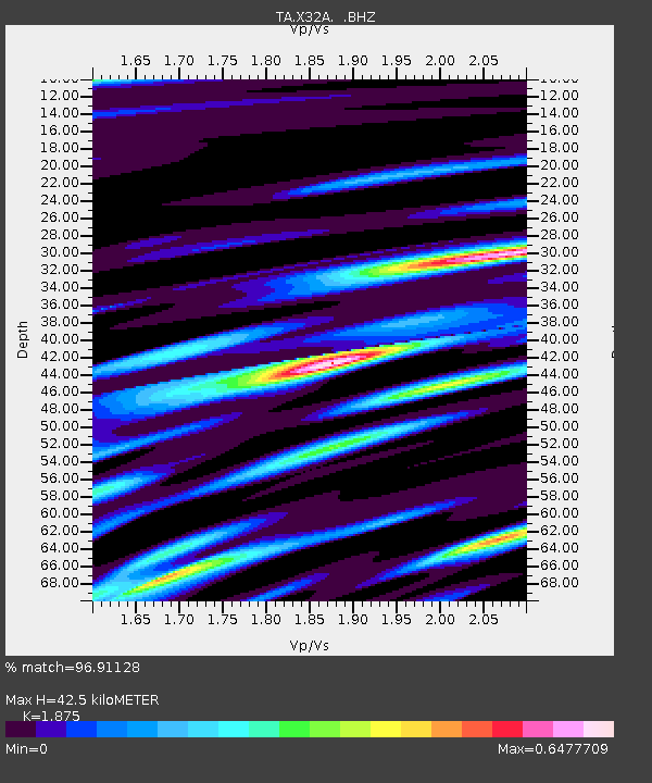
| Estimated Moho Depth: |
42.5 km |
| Estimated Crust Vp/Vs: |
1.88 |
| Assumed Crust Vp: |
6.315 km/s |
| Estimated Crust Vs: |
3.368 km/s |
| Estimated Crust Poisson's Ratio: |
0.30 |
|
| Radial Match: |
96.91128 % |
| Radial Bump: |
323 |
| Transverse Match: |
87.23854 % |
| Transverse Bump: |
400 |
| SOD ConfigId: |
319893 |
| Insert Time: |
2011-01-05 20:49:20.219 +0000 |
| GWidth: |
2.5 |
| Max Bumps: |
400 |
| Tol: |
0.001 |
|

Signal To Noise
| Channel | StoN | STA | LTA |
| TA:X32A: :BHZ:20100812T12:01:08.250013Z | 95.25581 | 6.6058606E-6 | 6.934864E-8 |
| TA:X32A: :BHN:20100812T12:01:08.250013Z | 31.480486 | 2.1894355E-6 | 6.9548975E-8 |
| TA:X32A: :BHE:20100812T12:01:08.250013Z | 27.644201 | 1.6671681E-6 | 6.030806E-8 |
| Arrivals |
| Ps | 6.3 SECOND |
| PpPs | 18 SECOND |
| PsPs/PpSs | 24 SECOND |


