You are here: Home > Network List > UU - University of Utah Regional Network Stations List
> Station FORU South Mineral Mountains, UT, USA > Earthquake Result Viewer
FORU South Mineral Mountains, UT, USA - Earthquake Result Viewer

| Earthquake location: |
Central Peru |
| Earthquake latitude/longitude: |
-14.7/-70.1 |
| Earthquake time(UTC): |
2019/03/01 (060) 08:50:41 GMT |
| Earthquake Depth: |
257 km |
| Earthquake Magnitude: |
7.0 mww |
| Earthquake Catalog/Contributor: |
NEIC PDE/us |
|
| Network: |
UU University of Utah Regional Network |
| Station: |
FORU South Mineral Mountains, UT, USA |
| Lat/Lon: |
38.46 N/112.86 W |
| Elevation: |
1840 m |
|
| Distance: |
66.3 deg |
| Az: |
324.419 deg |
| Baz: |
134.173 deg |
| Ray Param: |
0.056922197 |
| Estimated Moho Depth: |
34.25 km |
| Estimated Crust Vp/Vs: |
1.84 |
| Assumed Crust Vp: |
6.276 km/s |
| Estimated Crust Vs: |
3.415 km/s |
| Estimated Crust Poisson's Ratio: |
0.29 |
|
| Radial Match: |
92.82695 % |
| Radial Bump: |
400 |
| Transverse Match: |
86.037445 % |
| Transverse Bump: |
400 |
| SOD ConfigId: |
3313551 |
| Insert Time: |
2019-03-15 09:10:14.155 +0000 |
| GWidth: |
2.5 |
| Max Bumps: |
400 |
| Tol: |
0.001 |
|
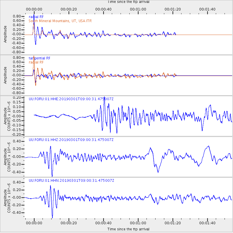
Signal To Noise
| Channel | StoN | STA | LTA |
| UU:FORU:01:HHZ:20190301T09:00:31.475007Z | 7.922916 | 4.758244E-8 | 6.005673E-9 |
| UU:FORU:01:HHN:20190301T09:00:31.475007Z | 2.4409175 | 2.5457178E-8 | 1.0429348E-8 |
| UU:FORU:01:HHE:20190301T09:00:31.475007Z | 0.8047627 | 1.0302587E-8 | 1.2802019E-8 |
| Arrivals |
| Ps | 4.7 SECOND |
| PpPs | 15 SECOND |
| PsPs/PpSs | 20 SECOND |


