You are here: Home > Network List > GO - National Seismic Network of Georgia Stations List
> Station MINA Georgia, Mina > Earthquake Result Viewer
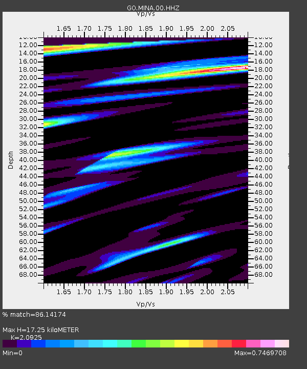
MINA Georgia, Mina - Earthquake Result Viewer
| Earthquake location: |
Mindanao, Philippines |
| Earthquake latitude/longitude: |
8.7/126.9 |
| Earthquake time(UTC): |
2023/12/03 (337) 14:36:01 GMT |
| Earthquake Depth: |
45 km |
| Earthquake Magnitude: |
5.8 mww |
| Earthquake Catalog/Contributor: |
NEIC PDE/us |
|
| Network: |
GO National Seismic Network of Georgia |
| Station: |
MINA Georgia, Mina |
| Lat/Lon: |
41.60 N/43.02 E |
| Elevation: |
1568 m |
|
| Distance: |
79.7 deg |
| Az: |
310.714 deg |
| Baz: |
87.482 deg |
| Ray Param: |
0.048702475 |
| Estimated Moho Depth: |
17.25 km |
| Estimated Crust Vp/Vs: |
2.09 |
| Assumed Crust Vp: |
6.419 km/s |
| Estimated Crust Vs: |
3.068 km/s |
| Estimated Crust Poisson's Ratio: |
0.35 |
|
| Radial Match: |
86.14174 % |
| Radial Bump: |
400 |
| Transverse Match: |
81.6725 % |
| Transverse Bump: |
400 |
| SOD ConfigId: |
33232451 |
| Insert Time: |
2023-12-17 14:44:51.751 +0000 |
| GWidth: |
2.5 |
| Max Bumps: |
400 |
| Tol: |
0.001 |
|

Signal To Noise
| Channel | StoN | STA | LTA |
| GO:MINA:00:HHZ:20231203T14:47:33.05997Z | 6.688099 | 2.811288E-7 | 4.2034184E-8 |
| GO:MINA:00:HHN:20231203T14:47:33.05997Z | 1.3959969 | 1.0042826E-7 | 7.194017E-8 |
| GO:MINA:00:HHE:20231203T14:47:33.05997Z | 1.3338367 | 6.131806E-8 | 4.597119E-8 |
| Arrivals |
| Ps | 3.0 SECOND |
| PpPs | 8.1 SECOND |
| PsPs/PpSs | 11 SECOND |


