You are here: Home > Network List > TA - USArray Transportable Network (new EarthScope stations) Stations List
> Station V32A Arapaho, OK, USA > Earthquake Result Viewer
V32A Arapaho, OK, USA - Earthquake Result Viewer

| Earthquake location: |
Ecuador |
| Earthquake latitude/longitude: |
-1.3/-77.3 |
| Earthquake time(UTC): |
2010/08/12 (224) 11:54:15 GMT |
| Earthquake Depth: |
207 km |
| Earthquake Magnitude: |
6.4 MB, 7.1 MW, 7.1 MW |
| Earthquake Catalog/Contributor: |
WHDF/NEIC |
|
| Network: |
TA USArray Transportable Network (new EarthScope stations) |
| Station: |
V32A Arapaho, OK, USA |
| Lat/Lon: |
35.72 N/99.04 W |
| Elevation: |
533 m |
|
| Distance: |
42.0 deg |
| Az: |
333.242 deg |
| Baz: |
146.416 deg |
| Ray Param: |
0.072630875 |
| Estimated Moho Depth: |
10.0 km |
| Estimated Crust Vp/Vs: |
1.62 |
| Assumed Crust Vp: |
6.315 km/s |
| Estimated Crust Vs: |
3.898 km/s |
| Estimated Crust Poisson's Ratio: |
0.19 |
|
| Radial Match: |
95.16054 % |
| Radial Bump: |
400 |
| Transverse Match: |
88.316574 % |
| Transverse Bump: |
400 |
| SOD ConfigId: |
319893 |
| Insert Time: |
2011-01-05 20:49:53.643 +0000 |
| GWidth: |
2.5 |
| Max Bumps: |
400 |
| Tol: |
0.001 |
|
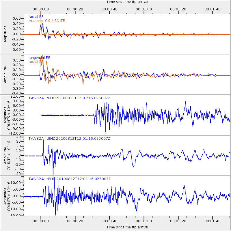
Signal To Noise
| Channel | StoN | STA | LTA |
| TA:V32A: :BHZ:20100812T12:01:16.025007Z | 88.848854 | 1.0678647E-5 | 1.2018891E-7 |
| TA:V32A: :BHN:20100812T12:01:16.025007Z | 28.13625 | 3.451832E-6 | 1.2268274E-7 |
| TA:V32A: :BHE:20100812T12:01:16.025007Z | 27.798613 | 3.239503E-6 | 1.165347E-7 |
| Arrivals |
| Ps | 1.1 SECOND |
| PpPs | 3.9 SECOND |
| PsPs/PpSs | 4.9 SECOND |


