You are here: Home > Network List > AK - Alaska Regional Network Stations List
> Station ISLE Juniper Island, AK, USA > Earthquake Result Viewer
ISLE Juniper Island, AK, USA - Earthquake Result Viewer
| Earthquake location: |
Mindanao, Philippines |
| Earthquake latitude/longitude: |
9.0/126.6 |
| Earthquake time(UTC): |
2023/12/03 (337) 19:49:36 GMT |
| Earthquake Depth: |
29 km |
| Earthquake Magnitude: |
6.9 Mww |
| Earthquake Catalog/Contributor: |
NEIC PDE/us |
|
| Network: |
AK Alaska Regional Network |
| Station: |
ISLE Juniper Island, AK, USA |
| Lat/Lon: |
60.60 N/142.34 W |
| Elevation: |
1425 m |
|
| Distance: |
82.8 deg |
| Az: |
29.817 deg |
| Baz: |
275.315 deg |
| Ray Param: |
0.046618436 |
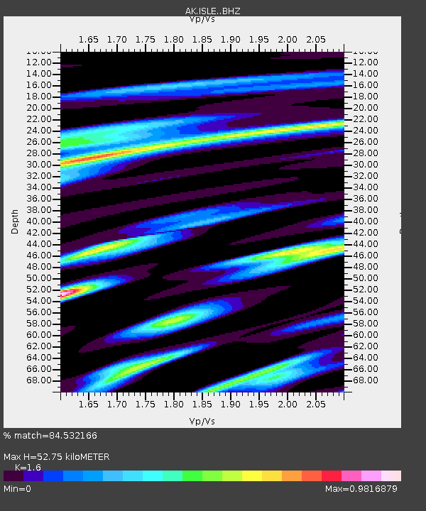
| Estimated Moho Depth: |
52.75 km |
| Estimated Crust Vp/Vs: |
1.60 |
| Assumed Crust Vp: |
6.566 km/s |
| Estimated Crust Vs: |
4.104 km/s |
| Estimated Crust Poisson's Ratio: |
0.18 |
|
| Radial Match: |
84.532166 % |
| Radial Bump: |
400 |
| Transverse Match: |
73.373566 % |
| Transverse Bump: |
400 |
| SOD ConfigId: |
33232451 |
| Insert Time: |
2023-12-17 19:54:03.890 +0000 |
| GWidth: |
2.5 |
| Max Bumps: |
400 |
| Tol: |
0.001 |
|

Signal To Noise
| Channel | StoN | STA | LTA |
| AK:ISLE: :BHZ:20231203T20:01:26.967976Z | 2.0468936 | 1.4653538E-6 | 7.158915E-7 |
| AK:ISLE: :BHN:20231203T20:01:26.967976Z | 1.1324542 | 7.9959057E-7 | 7.060688E-7 |
| AK:ISLE: :BHE:20231203T20:01:26.967976Z | 1.6653482 | 1.0366583E-6 | 6.2248745E-7 |
| Arrivals |
| Ps | 5.0 SECOND |
| PpPs | 20 SECOND |
| PsPs/PpSs | 25 SECOND |


