You are here: Home > Network List > TA - USArray Transportable Network (new EarthScope stations) Stations List
> Station 339A Huntington, TX, USA > Earthquake Result Viewer
339A Huntington, TX, USA - Earthquake Result Viewer
| Earthquake location: |
Ecuador |
| Earthquake latitude/longitude: |
-1.3/-77.3 |
| Earthquake time(UTC): |
2010/08/12 (224) 11:54:15 GMT |
| Earthquake Depth: |
207 km |
| Earthquake Magnitude: |
6.4 MB, 7.1 MW, 7.1 MW |
| Earthquake Catalog/Contributor: |
WHDF/NEIC |
|
| Network: |
TA USArray Transportable Network (new EarthScope stations) |
| Station: |
339A Huntington, TX, USA |
| Lat/Lon: |
31.33 N/94.56 W |
| Elevation: |
82 m |
|
| Distance: |
36.3 deg |
| Az: |
334.636 deg |
| Baz: |
149.969 deg |
| Ray Param: |
0.07597839 |
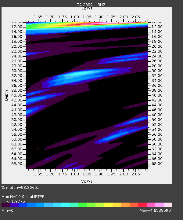
| Estimated Moho Depth: |
10.0 km |
| Estimated Crust Vp/Vs: |
1.98 |
| Assumed Crust Vp: |
5.738 km/s |
| Estimated Crust Vs: |
2.902 km/s |
| Estimated Crust Poisson's Ratio: |
0.33 |
|
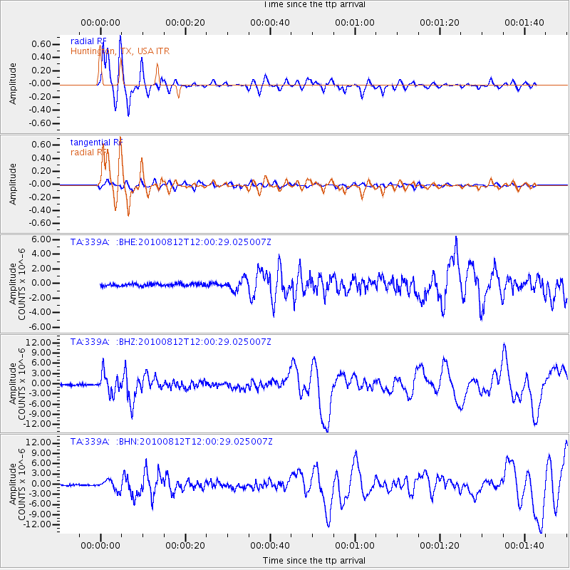
| Radial Match: |
93.30651 % |
| Radial Bump: |
328 |
| Transverse Match: |
78.343376 % |
| Transverse Bump: |
400 |
| SOD ConfigId: |
319893 |
| Insert Time: |
2011-01-05 20:53:13.859 +0000 |
| GWidth: |
2.5 |
| Max Bumps: |
400 |
| Tol: |
0.001 |
|
Signal To Noise
| Channel | StoN | STA | LTA |
| TA:339A: :BHZ:20100812T12:00:29.025007Z | 16.487553 | 2.8613297E-6 | 1.7354485E-7 |
| TA:339A: :BHN:20100812T12:00:29.025007Z | 9.616525 | 1.4730583E-6 | 1.5317991E-7 |
| TA:339A: :BHE:20100812T12:00:29.025007Z | 4.5233626 | 7.6486583E-7 | 1.690923E-7 |
| Arrivals |
| Ps | 1.8 SECOND |
| PpPs | 4.9 SECOND |
| PsPs/PpSs | 6.7 SECOND |


