You are here: Home > Network List > TA - USArray Transportable Network (new EarthScope stations) Stations List
> Station 340A Bronson, TX, USA > Earthquake Result Viewer
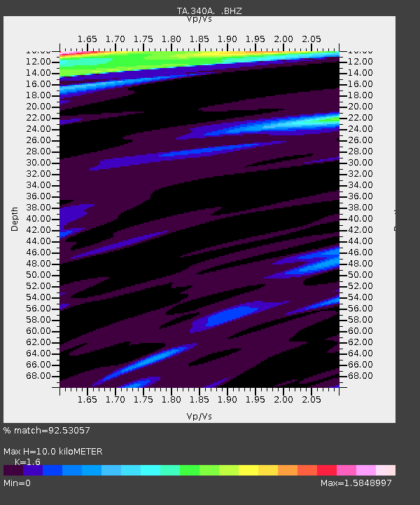
340A Bronson, TX, USA - Earthquake Result Viewer
| Earthquake location: |
Ecuador |
| Earthquake latitude/longitude: |
-1.3/-77.3 |
| Earthquake time(UTC): |
2010/08/12 (224) 11:54:15 GMT |
| Earthquake Depth: |
207 km |
| Earthquake Magnitude: |
6.4 MB, 7.1 MW, 7.1 MW |
| Earthquake Catalog/Contributor: |
WHDF/NEIC |
|
| Network: |
TA USArray Transportable Network (new EarthScope stations) |
| Station: |
340A Bronson, TX, USA |
| Lat/Lon: |
31.42 N/93.89 W |
| Elevation: |
57 m |
|
| Distance: |
36.1 deg |
| Az: |
335.545 deg |
| Baz: |
151.047 deg |
| Ray Param: |
0.07609427 |
| Estimated Moho Depth: |
10.0 km |
| Estimated Crust Vp/Vs: |
1.60 |
| Assumed Crust Vp: |
6.065 km/s |
| Estimated Crust Vs: |
3.79 km/s |
| Estimated Crust Poisson's Ratio: |
0.18 |
|
| Radial Match: |
92.53057 % |
| Radial Bump: |
294 |
| Transverse Match: |
84.11829 % |
| Transverse Bump: |
379 |
| SOD ConfigId: |
319893 |
| Insert Time: |
2011-01-05 20:53:24.802 +0000 |
| GWidth: |
2.5 |
| Max Bumps: |
400 |
| Tol: |
0.001 |
|

Signal To Noise
| Channel | StoN | STA | LTA |
| TA:340A: :BHZ:20100812T12:00:27.275007Z | 51.254097 | 4.0832992E-6 | 7.966777E-8 |
| TA:340A: :BHN:20100812T12:00:27.275007Z | 12.41234 | 1.7105907E-6 | 1.3781371E-7 |
| TA:340A: :BHE:20100812T12:00:27.275007Z | 11.7783575 | 9.997431E-7 | 8.4879666E-8 |
| Arrivals |
| Ps | 1.1 SECOND |
| PpPs | 4.0 SECOND |
| PsPs/PpSs | 5.1 SECOND |


