You are here: Home > Network List > TA - USArray Transportable Network (new EarthScope stations) Stations List
> Station 239A Gary, TX, USA > Earthquake Result Viewer
239A Gary, TX, USA - Earthquake Result Viewer
| Earthquake location: |
Ecuador |
| Earthquake latitude/longitude: |
-1.3/-77.3 |
| Earthquake time(UTC): |
2010/08/12 (224) 11:54:15 GMT |
| Earthquake Depth: |
207 km |
| Earthquake Magnitude: |
6.4 MB, 7.1 MW, 7.1 MW |
| Earthquake Catalog/Contributor: |
WHDF/NEIC |
|
| Network: |
TA USArray Transportable Network (new EarthScope stations) |
| Station: |
239A Gary, TX, USA |
| Lat/Lon: |
32.02 N/94.47 W |
| Elevation: |
100 m |
|
| Distance: |
36.9 deg |
| Az: |
335.31 deg |
| Baz: |
150.554 deg |
| Ray Param: |
0.07566101 |
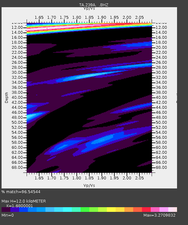
| Estimated Moho Depth: |
12.0 km |
| Estimated Crust Vp/Vs: |
1.68 |
| Assumed Crust Vp: |
6.245 km/s |
| Estimated Crust Vs: |
3.717 km/s |
| Estimated Crust Poisson's Ratio: |
0.23 |
|
| Radial Match: |
96.54544 % |
| Radial Bump: |
373 |
| Transverse Match: |
88.12507 % |
| Transverse Bump: |
400 |
| SOD ConfigId: |
319893 |
| Insert Time: |
2011-01-05 20:53:33.523 +0000 |
| GWidth: |
2.5 |
| Max Bumps: |
400 |
| Tol: |
0.001 |
|

Signal To Noise
| Channel | StoN | STA | LTA |
| TA:239A: :BHZ:20100812T12:00:33.724989Z | 63.444103 | 6.5211448E-6 | 1.0278567E-7 |
| TA:239A: :BHN:20100812T12:00:33.724989Z | 13.855798 | 2.4575272E-6 | 1.7736456E-7 |
| TA:239A: :BHE:20100812T12:00:33.724989Z | 7.689048 | 1.202294E-6 | 1.5636448E-7 |
| Arrivals |
| Ps | 1.4 SECOND |
| PpPs | 4.8 SECOND |
| PsPs/PpSs | 6.2 SECOND |


