You are here: Home > Network List > AV - Alaska Volcano Observatory Stations List
> Station MAPS Pakushin Southeast, Makushin Volcano, Alaska > Earthquake Result Viewer
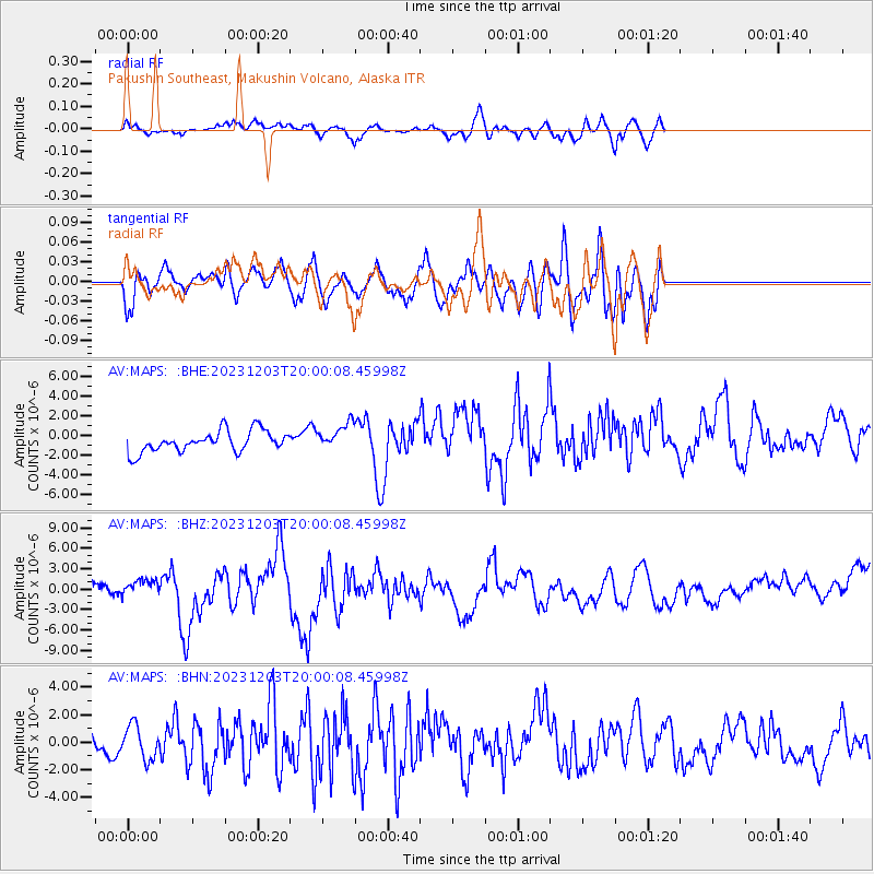
MAPS Pakushin Southeast, Makushin Volcano, Alaska - Earthquake Result Viewer
*The percent match for this event was below the threshold and hence no stack was calculated.
| Earthquake location: |
Mindanao, Philippines |
| Earthquake latitude/longitude: |
9.0/126.6 |
| Earthquake time(UTC): |
2023/12/03 (337) 19:49:36 GMT |
| Earthquake Depth: |
29 km |
| Earthquake Magnitude: |
6.9 Mww |
| Earthquake Catalog/Contributor: |
NEIC PDE/us |
|
| Network: |
AV Alaska Volcano Observatory |
| Station: |
MAPS Pakushin Southeast, Makushin Volcano, Alaska |
| Lat/Lon: |
53.81 N/166.94 W |
| Elevation: |
333 m |
|
| Distance: |
69.0 deg |
| Az: |
35.619 deg |
| Baz: |
255.973 deg |
| Ray Param: |
$rayparam |
*The percent match for this event was below the threshold and hence was not used in the summary stack. |
|
| Radial Match: |
55.376644 % |
| Radial Bump: |
291 |
| Transverse Match: |
59.092953 % |
| Transverse Bump: |
385 |
| SOD ConfigId: |
33232451 |
| Insert Time: |
2023-12-17 19:57:48.632 +0000 |
| GWidth: |
2.5 |
| Max Bumps: |
400 |
| Tol: |
0.001 |
|
Signal To Noise
| Channel | StoN | STA | LTA |
| AV:MAPS: :BHZ:20231203T20:00:08.45998Z | 1.6711502 | 1.327784E-6 | 7.945331E-7 |
| AV:MAPS: :BHN:20231203T20:00:08.45998Z | 1.0792059 | 1.2199047E-6 | 1.1303725E-6 |
| AV:MAPS: :BHE:20231203T20:00:08.45998Z | 1.2590182 | 1.3574178E-6 | 1.0781558E-6 |
| Arrivals |
| Ps | |
| PpPs | |
| PsPs/PpSs | |


