You are here: Home > Network List > TA - USArray Transportable Network (new EarthScope stations) Stations List
> Station V35A Meyer Ranch, Chandler, OK, USA > Earthquake Result Viewer
V35A Meyer Ranch, Chandler, OK, USA - Earthquake Result Viewer

| Earthquake location: |
Ecuador |
| Earthquake latitude/longitude: |
-1.3/-77.3 |
| Earthquake time(UTC): |
2010/08/12 (224) 11:54:15 GMT |
| Earthquake Depth: |
207 km |
| Earthquake Magnitude: |
6.4 MB, 7.1 MW, 7.1 MW |
| Earthquake Catalog/Contributor: |
WHDF/NEIC |
|
| Network: |
TA USArray Transportable Network (new EarthScope stations) |
| Station: |
V35A Meyer Ranch, Chandler, OK, USA |
| Lat/Lon: |
35.76 N/96.84 W |
| Elevation: |
280 m |
|
| Distance: |
41.1 deg |
| Az: |
335.568 deg |
| Baz: |
149.44 deg |
| Ray Param: |
0.07318832 |
| Estimated Moho Depth: |
25.75 km |
| Estimated Crust Vp/Vs: |
1.96 |
| Assumed Crust Vp: |
6.426 km/s |
| Estimated Crust Vs: |
3.279 km/s |
| Estimated Crust Poisson's Ratio: |
0.32 |
|
| Radial Match: |
94.226425 % |
| Radial Bump: |
329 |
| Transverse Match: |
82.10345 % |
| Transverse Bump: |
400 |
| SOD ConfigId: |
319893 |
| Insert Time: |
2011-01-05 20:53:55.464 +0000 |
| GWidth: |
2.5 |
| Max Bumps: |
400 |
| Tol: |
0.001 |
|
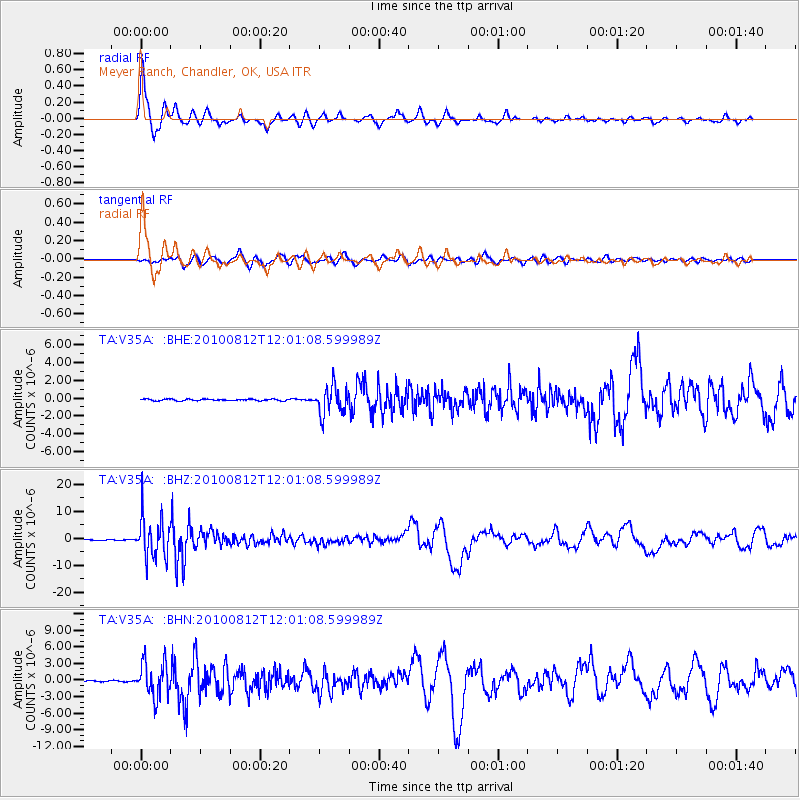
Signal To Noise
| Channel | StoN | STA | LTA |
| TA:V35A: :BHZ:20100812T12:01:08.599989Z | 105.2969 | 7.4292316E-6 | 7.055508E-8 |
| TA:V35A: :BHN:20100812T12:01:08.599989Z | 22.67429 | 3.1411348E-6 | 1.3853288E-7 |
| TA:V35A: :BHE:20100812T12:01:08.599989Z | 17.42749 | 1.5687139E-6 | 9.001375E-8 |
| Arrivals |
| Ps | 4.1 SECOND |
| PpPs | 11 SECOND |
| PsPs/PpSs | 15 SECOND |


