You are here: Home > Network List > WI - West Indies IPGP Network Stations List
> Station MAGL Barre de l'ile, Marie-Galante, Guadeloupe > Earthquake Result Viewer
MAGL Barre de l'ile, Marie-Galante, Guadeloupe - Earthquake Result Viewer
| Earthquake location: |
Central Peru |
| Earthquake latitude/longitude: |
-14.7/-70.1 |
| Earthquake time(UTC): |
2019/03/01 (060) 08:50:41 GMT |
| Earthquake Depth: |
257 km |
| Earthquake Magnitude: |
7.0 mww |
| Earthquake Catalog/Contributor: |
NEIC PDE/us |
|
| Network: |
WI West Indies IPGP Network |
| Station: |
MAGL Barre de l'ile, Marie-Galante, Guadeloupe |
| Lat/Lon: |
15.95 N/61.28 W |
| Elevation: |
159 m |
|
| Distance: |
31.7 deg |
| Az: |
16.364 deg |
| Baz: |
196.465 deg |
| Ray Param: |
0.07814853 |
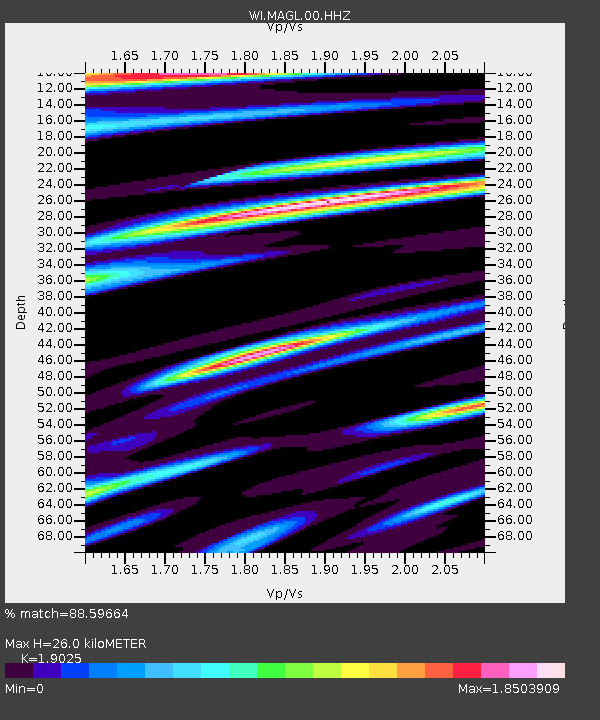
| Estimated Moho Depth: |
26.0 km |
| Estimated Crust Vp/Vs: |
1.90 |
| Assumed Crust Vp: |
5.88 km/s |
| Estimated Crust Vs: |
3.091 km/s |
| Estimated Crust Poisson's Ratio: |
0.31 |
|
| Radial Match: |
88.59664 % |
| Radial Bump: |
400 |
| Transverse Match: |
61.27929 % |
| Transverse Bump: |
400 |
| SOD ConfigId: |
3313551 |
| Insert Time: |
2019-03-15 09:11:17.810 +0000 |
| GWidth: |
2.5 |
| Max Bumps: |
400 |
| Tol: |
0.001 |
|
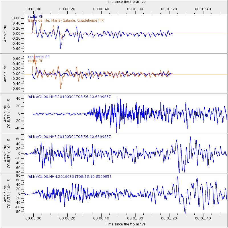
Signal To Noise
| Channel | StoN | STA | LTA |
| WI:MAGL:00:HHZ:20190301T08:56:10.639985Z | 12.840623 | 1.7762086E-5 | 1.3832729E-6 |
| WI:MAGL:00:HHN:20190301T08:56:10.639985Z | 4.725361 | 6.836426E-6 | 1.4467522E-6 |
| WI:MAGL:00:HHE:20190301T08:56:10.639985Z | 2.481575 | 3.5450796E-6 | 1.4285603E-6 |
| Arrivals |
| Ps | 4.2 SECOND |
| PpPs | 12 SECOND |
| PsPs/PpSs | 16 SECOND |


