You are here: Home > Network List > TA - USArray Transportable Network (new EarthScope stations) Stations List
> Station R37A Teagarden Farms, La Cygne, KS, USA > Earthquake Result Viewer
R37A Teagarden Farms, La Cygne, KS, USA - Earthquake Result Viewer
| Earthquake location: |
Ecuador |
| Earthquake latitude/longitude: |
-1.3/-77.3 |
| Earthquake time(UTC): |
2010/08/12 (224) 11:54:15 GMT |
| Earthquake Depth: |
207 km |
| Earthquake Magnitude: |
6.4 MB, 7.1 MW, 7.1 MW |
| Earthquake Catalog/Contributor: |
WHDF/NEIC |
|
| Network: |
TA USArray Transportable Network (new EarthScope stations) |
| Station: |
R37A Teagarden Farms, La Cygne, KS, USA |
| Lat/Lon: |
38.31 N/94.83 W |
| Elevation: |
298 m |
|
| Distance: |
42.6 deg |
| Az: |
339.506 deg |
| Baz: |
153.58 deg |
| Ray Param: |
0.07227717 |
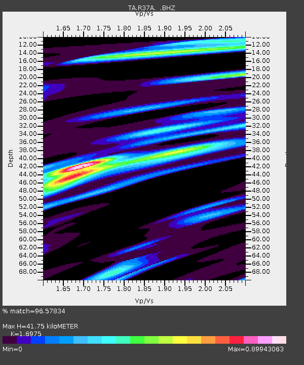
| Estimated Moho Depth: |
41.75 km |
| Estimated Crust Vp/Vs: |
1.70 |
| Assumed Crust Vp: |
6.498 km/s |
| Estimated Crust Vs: |
3.828 km/s |
| Estimated Crust Poisson's Ratio: |
0.23 |
|
| Radial Match: |
96.57834 % |
| Radial Bump: |
352 |
| Transverse Match: |
78.53543 % |
| Transverse Bump: |
400 |
| SOD ConfigId: |
319893 |
| Insert Time: |
2011-01-05 20:53:59.843 +0000 |
| GWidth: |
2.5 |
| Max Bumps: |
400 |
| Tol: |
0.001 |
|

Signal To Noise
| Channel | StoN | STA | LTA |
| TA:R37A: :BHZ:20100812T12:01:20.474989Z | 97.70194 | 4.7995254E-6 | 4.9124157E-8 |
| TA:R37A: :BHN:20100812T12:01:20.474989Z | 28.772331 | 2.863359E-6 | 9.951779E-8 |
| TA:R37A: :BHE:20100812T12:01:20.474989Z | 34.361515 | 1.6537034E-6 | 4.8126616E-8 |
| Arrivals |
| Ps | 4.8 SECOND |
| PpPs | 16 SECOND |
| PsPs/PpSs | 21 SECOND |


