You are here: Home > Network List > G - GEOSCOPE Stations List
> Station ATD Arta Cave - Arta, Republic of Djibouti > Earthquake Result Viewer
ATD Arta Cave - Arta, Republic of Djibouti - Earthquake Result Viewer
| Earthquake location: |
Mindanao, Philippines |
| Earthquake latitude/longitude: |
9.0/126.6 |
| Earthquake time(UTC): |
2023/12/03 (337) 19:49:36 GMT |
| Earthquake Depth: |
29 km |
| Earthquake Magnitude: |
6.9 Mww |
| Earthquake Catalog/Contributor: |
NEIC PDE/us |
|
| Network: |
G GEOSCOPE |
| Station: |
ATD Arta Cave - Arta, Republic of Djibouti |
| Lat/Lon: |
11.53 N/42.85 E |
| Elevation: |
610 m |
|
| Distance: |
82.2 deg |
| Az: |
280.455 deg |
| Baz: |
82.446 deg |
| Ray Param: |
0.047022525 |
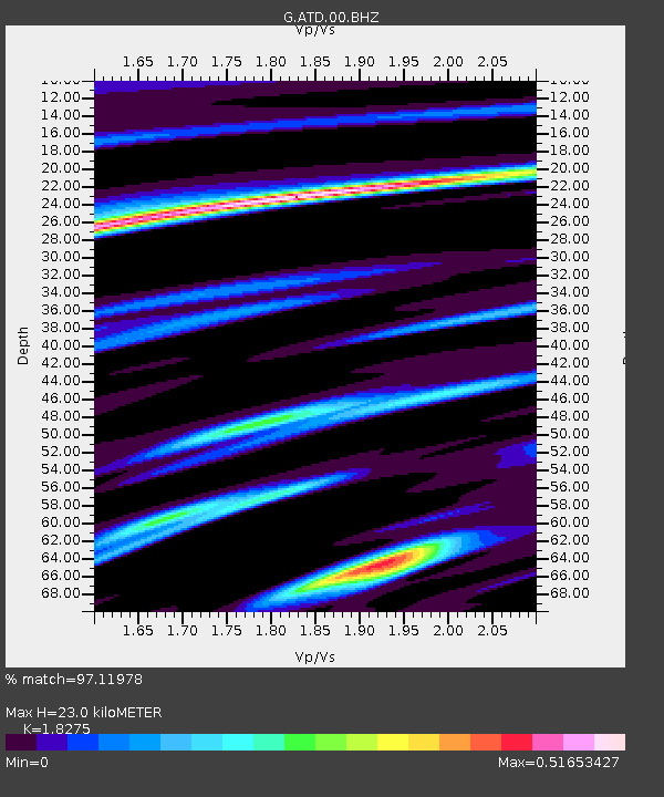
| Estimated Moho Depth: |
23.0 km |
| Estimated Crust Vp/Vs: |
1.83 |
| Assumed Crust Vp: |
6.375 km/s |
| Estimated Crust Vs: |
3.488 km/s |
| Estimated Crust Poisson's Ratio: |
0.29 |
|
| Radial Match: |
97.11978 % |
| Radial Bump: |
293 |
| Transverse Match: |
89.83054 % |
| Transverse Bump: |
400 |
| SOD ConfigId: |
33232451 |
| Insert Time: |
2023-12-17 20:00:21.200 +0000 |
| GWidth: |
2.5 |
| Max Bumps: |
400 |
| Tol: |
0.001 |
|
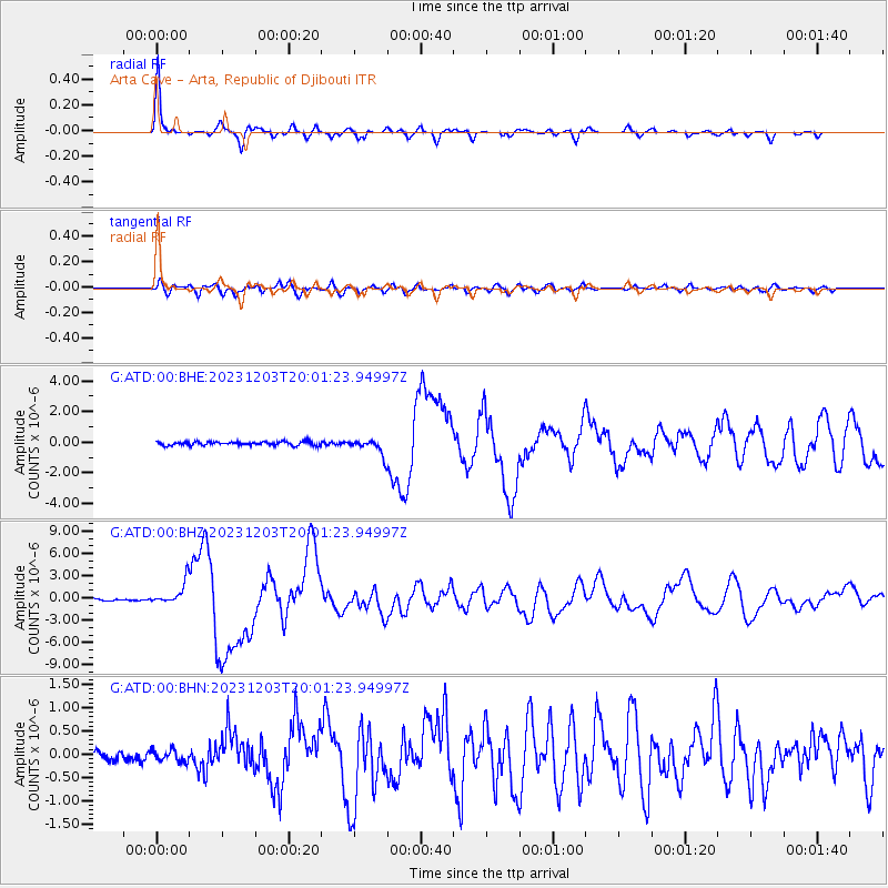
Signal To Noise
| Channel | StoN | STA | LTA |
| G:ATD:00:BHZ:20231203T20:01:23.94997Z | 14.611325 | 1.5639806E-6 | 1.0703893E-7 |
| G:ATD:00:BHN:20231203T20:01:23.94997Z | 1.1463265 | 1.303827E-7 | 1.1373958E-7 |
| G:ATD:00:BHE:20231203T20:01:23.94997Z | 4.1069474 | 5.1548574E-7 | 1.2551554E-7 |
| Arrivals |
| Ps | 3.1 SECOND |
| PpPs | 9.9 SECOND |
| PsPs/PpSs | 13 SECOND |


