You are here: Home > Network List > TA - USArray Transportable Network (new EarthScope stations) Stations List
> Station X35A Drake, OK, USA > Earthquake Result Viewer
X35A Drake, OK, USA - Earthquake Result Viewer

| Earthquake location: |
Ecuador |
| Earthquake latitude/longitude: |
-1.3/-77.3 |
| Earthquake time(UTC): |
2010/08/12 (224) 11:54:15 GMT |
| Earthquake Depth: |
207 km |
| Earthquake Magnitude: |
6.4 MB, 7.1 MW, 7.1 MW |
| Earthquake Catalog/Contributor: |
WHDF/NEIC |
|
| Network: |
TA USArray Transportable Network (new EarthScope stations) |
| Station: |
X35A Drake, OK, USA |
| Lat/Lon: |
34.40 N/96.97 W |
| Elevation: |
300 m |
|
| Distance: |
40.0 deg |
| Az: |
334.342 deg |
| Baz: |
148.431 deg |
| Ray Param: |
0.0738628 |
| Estimated Moho Depth: |
21.75 km |
| Estimated Crust Vp/Vs: |
2.10 |
| Assumed Crust Vp: |
6.426 km/s |
| Estimated Crust Vs: |
3.064 km/s |
| Estimated Crust Poisson's Ratio: |
0.35 |
|
| Radial Match: |
97.3886 % |
| Radial Bump: |
382 |
| Transverse Match: |
93.258995 % |
| Transverse Bump: |
400 |
| SOD ConfigId: |
319893 |
| Insert Time: |
2011-01-05 20:54:50.129 +0000 |
| GWidth: |
2.5 |
| Max Bumps: |
400 |
| Tol: |
0.001 |
|
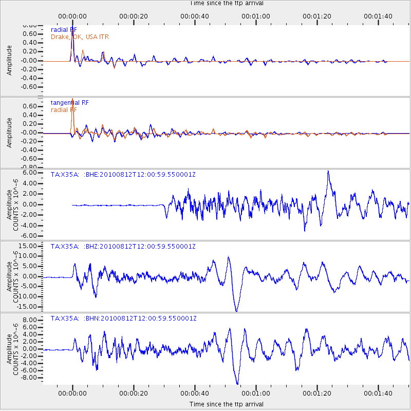
Signal To Noise
| Channel | StoN | STA | LTA |
| TA:X35A: :BHZ:20100812T12:00:59.550001Z | 56.43141 | 3.0192853E-6 | 5.3503626E-8 |
| TA:X35A: :BHN:20100812T12:00:59.550001Z | 40.2767 | 1.4714946E-6 | 3.653464E-8 |
| TA:X35A: :BHE:20100812T12:00:59.550001Z | 21.75776 | 9.805394E-7 | 4.5066198E-8 |
| Arrivals |
| Ps | 3.9 SECOND |
| PpPs | 9.9 SECOND |
| PsPs/PpSs | 14 SECOND |


