You are here: Home > Network List > II - Global Seismograph Network (GSN - IRIS/IDA) Stations List
> Station COCO West Island, Cocos (Keeling) Islands > Earthquake Result Viewer
COCO West Island, Cocos (Keeling) Islands - Earthquake Result Viewer
| Earthquake location: |
Mindanao, Philippines |
| Earthquake latitude/longitude: |
9.0/126.6 |
| Earthquake time(UTC): |
2023/12/03 (337) 19:49:36 GMT |
| Earthquake Depth: |
29 km |
| Earthquake Magnitude: |
6.9 Mww |
| Earthquake Catalog/Contributor: |
NEIC PDE/us |
|
| Network: |
II Global Seismograph Network (GSN - IRIS/IDA) |
| Station: |
COCO West Island, Cocos (Keeling) Islands |
| Lat/Lon: |
12.19 S/96.83 E |
| Elevation: |
1.0 m |
|
| Distance: |
36.3 deg |
| Az: |
235.126 deg |
| Baz: |
55.995 deg |
| Ray Param: |
0.07673872 |
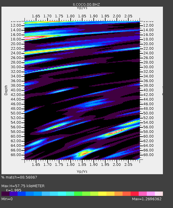
| Estimated Moho Depth: |
57.75 km |
| Estimated Crust Vp/Vs: |
2.00 |
| Assumed Crust Vp: |
4.24 km/s |
| Estimated Crust Vs: |
2.125 km/s |
| Estimated Crust Poisson's Ratio: |
0.33 |
|
| Radial Match: |
88.56867 % |
| Radial Bump: |
345 |
| Transverse Match: |
71.695885 % |
| Transverse Bump: |
400 |
| SOD ConfigId: |
33232451 |
| Insert Time: |
2023-12-17 20:01:50.281 +0000 |
| GWidth: |
2.5 |
| Max Bumps: |
400 |
| Tol: |
0.001 |
|
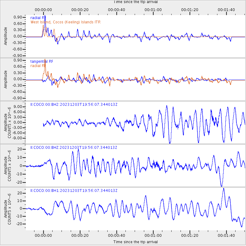
Signal To Noise
| Channel | StoN | STA | LTA |
| II:COCO:00:BHZ:20231203T19:56:07.344013Z | 8.84892 | 4.4962426E-6 | 5.0811207E-7 |
| II:COCO:00:BH1:20231203T19:56:07.344013Z | 6.0048614 | 5.5020773E-6 | 9.1627044E-7 |
| II:COCO:00:BH2:20231203T19:56:07.344013Z | 0.89819324 | 8.844442E-7 | 9.846926E-7 |
| Arrivals |
| Ps | 14 SECOND |
| PpPs | 40 SECOND |
| PsPs/PpSs | 54 SECOND |


