You are here: Home > Network List > TA - USArray Transportable Network (new EarthScope stations) Stations List
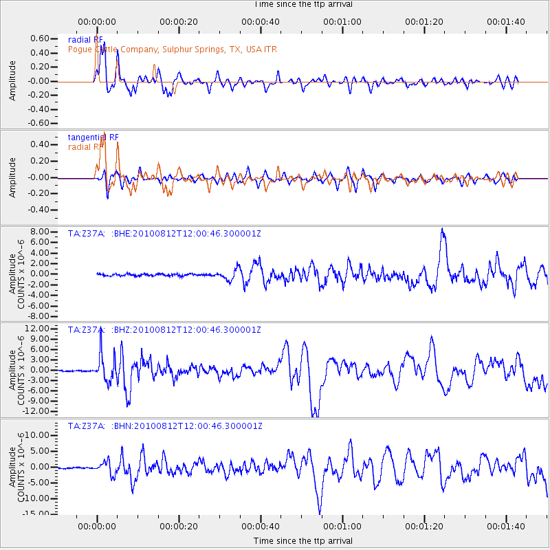
> Station Z37A Pogue Cattle Company, Sulphur Springs, TX, USA > Earthquake Result Viewer
Z37A Pogue Cattle Company, Sulphur Springs, TX, USA - Earthquake Result Viewer
| Earthquake location: |
Ecuador |
| Earthquake latitude/longitude: |
-1.3/-77.3 |
| Earthquake time(UTC): |
2010/08/12 (224) 11:54:15 GMT |
| Earthquake Depth: |
207 km |
| Earthquake Magnitude: |
6.4 MB, 7.1 MW, 7.1 MW |
| Earthquake Catalog/Contributor: |
WHDF/NEIC |
|
| Network: |
TA USArray Transportable Network (new EarthScope stations) |
| Station: |
Z37A Pogue Cattle Company, Sulphur Springs, TX, USA |
| Lat/Lon: |
33.20 N/95.62 W |
| Elevation: |
146 m |
|
| Distance: |
38.4 deg |
| Az: |
334.891 deg |
| Baz: |
149.604 deg |
| Ray Param: |
0.07480585 |
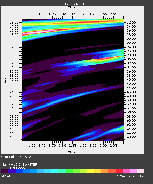
| Estimated Moho Depth: |
16.5 km |
| Estimated Crust Vp/Vs: |
1.69 |
| Assumed Crust Vp: |
6.245 km/s |
| Estimated Crust Vs: |
3.706 km/s |
| Estimated Crust Poisson's Ratio: |
0.23 |
|
| Radial Match: |
95.35701 % |
| Radial Bump: |
371 |
| Transverse Match: |
80.58677 % |
| Transverse Bump: |
400 |
| SOD ConfigId: |
319893 |
| Insert Time: |
2011-01-05 20:55:22.959 +0000 |
| GWidth: |
2.5 |
| Max Bumps: |
400 |
| Tol: |
0.001 |
|
Signal To Noise
| Channel | StoN | STA | LTA |
| TA:Z37A: :BHZ:20100812T12:00:46.300001Z | 33.682095 | 3.985805E-6 | 1.18336025E-7 |
| TA:Z37A: :BHN:20100812T12:00:46.300001Z | 16.011805 | 2.0136554E-6 | 1.2576068E-7 |
| TA:Z37A: :BHE:20100812T12:00:46.300001Z | 5.931357 | 1.0076888E-6 | 1.6989178E-7 |
| Arrivals |
| Ps | 1.9 SECOND |
| PpPs | 6.6 SECOND |
| PsPs/PpSs | 8.6 SECOND |


