You are here: Home > Network List > TA - USArray Transportable Network (new EarthScope stations) Stations List
> Station Z39A Irene McRaven, Queen City, TX, USA > Earthquake Result Viewer
Z39A Irene McRaven, Queen City, TX, USA - Earthquake Result Viewer
| Earthquake location: |
Ecuador |
| Earthquake latitude/longitude: |
-1.3/-77.3 |
| Earthquake time(UTC): |
2010/08/12 (224) 11:54:15 GMT |
| Earthquake Depth: |
207 km |
| Earthquake Magnitude: |
6.4 MB, 7.1 MW, 7.1 MW |
| Earthquake Catalog/Contributor: |
WHDF/NEIC |
|
| Network: |
TA USArray Transportable Network (new EarthScope stations) |
| Station: |
Z39A Irene McRaven, Queen City, TX, USA |
| Lat/Lon: |
33.24 N/94.18 W |
| Elevation: |
112 m |
|
| Distance: |
37.8 deg |
| Az: |
336.632 deg |
| Baz: |
151.76 deg |
| Ray Param: |
0.07512047 |
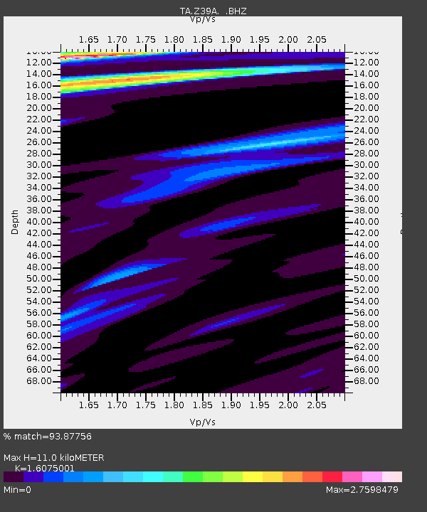
| Estimated Moho Depth: |
11.0 km |
| Estimated Crust Vp/Vs: |
1.61 |
| Assumed Crust Vp: |
6.245 km/s |
| Estimated Crust Vs: |
3.885 km/s |
| Estimated Crust Poisson's Ratio: |
0.18 |
|
| Radial Match: |
93.87756 % |
| Radial Bump: |
322 |
| Transverse Match: |
82.11107 % |
| Transverse Bump: |
400 |
| SOD ConfigId: |
319893 |
| Insert Time: |
2011-01-05 20:55:25.916 +0000 |
| GWidth: |
2.5 |
| Max Bumps: |
400 |
| Tol: |
0.001 |
|

Signal To Noise
| Channel | StoN | STA | LTA |
| TA:Z39A: :BHZ:20100812T12:00:41.699995Z | 30.168455 | 5.866854E-6 | 1.944698E-7 |
| TA:Z39A: :BHN:20100812T12:00:41.699995Z | 6.012694 | 2.6734003E-6 | 4.446261E-7 |
| TA:Z39A: :BHE:20100812T12:00:41.699995Z | 5.2557364 | 1.6163766E-6 | 3.0754524E-7 |
| Arrivals |
| Ps | 1.2 SECOND |
| PpPs | 4.3 SECOND |
| PsPs/PpSs | 5.4 SECOND |


